Maps
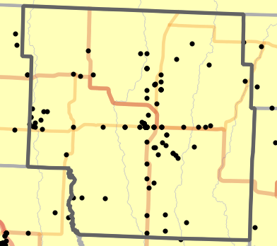
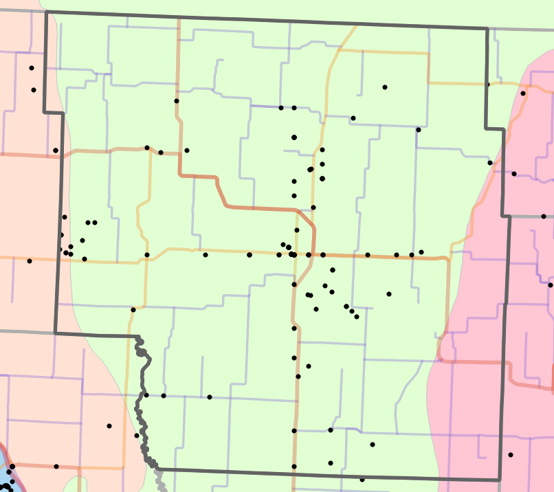
Landmark Map
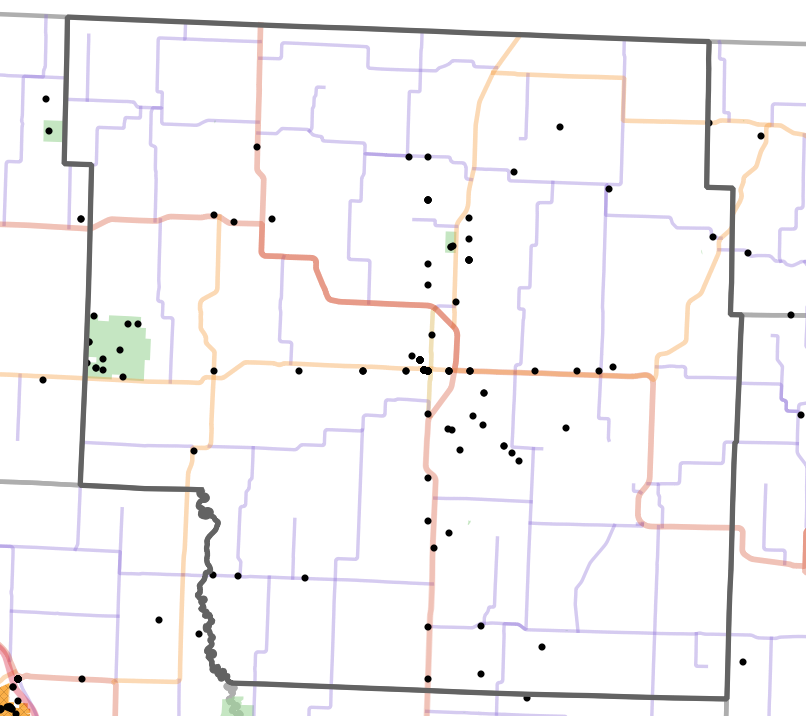
Landmark locality map for Nodaway County, Missouri
Map created 15 April 2026.
 | Interstate Highway |  | Railroad |  | US Army Corps of Engineers |
 | US Highway |  | Department of Conservation |  | US Fish and Wildlife Service |
 | State Highway |  | Department of Natural Resources |  | National Park Service |
 | County Highway |  | US Forest Service |  | US Department of Defense |
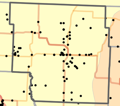
Locator Map
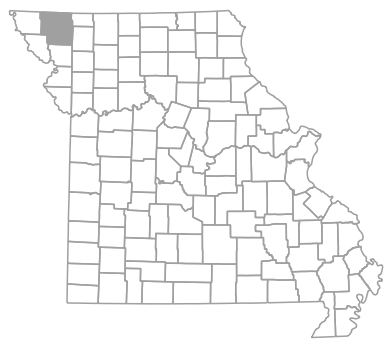
Locator map for Nodaway County, Missouri
Map created 15 April 2026.
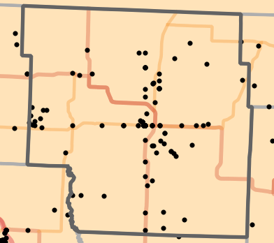
Natural Divisions Locality Map
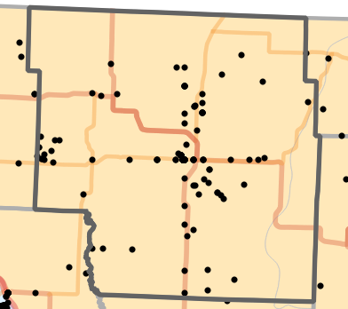
Natural Divisions locality map for Nodaway County, Missouri
Map created 15 April 2026.
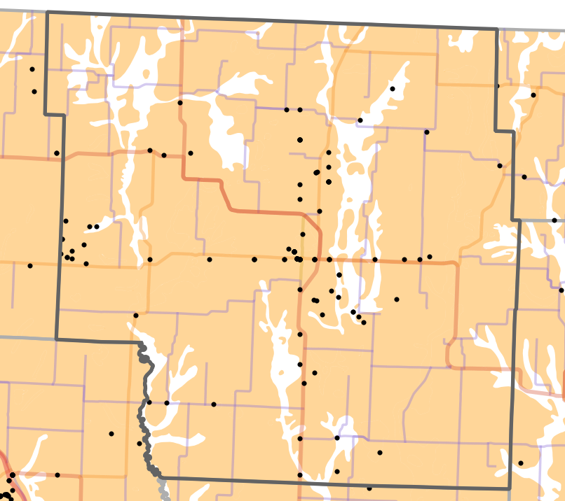
Ecological Drainage Unit Locality Map
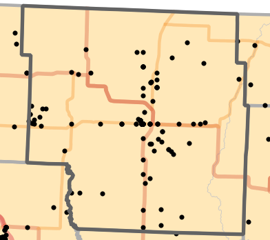
Ecological Drainage Units locality map for Nodaway County, Missouri
Map created 15 April 2026.
Major Watersheds Locality Map
Major Watersheds locality map for Nodaway County, Missouri
Map created 15 April 2026.
Major Rivers Locality Map
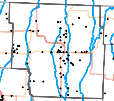
Major Rivers locality map for Nodaway County, Missouri
Map created 15 April 2026.
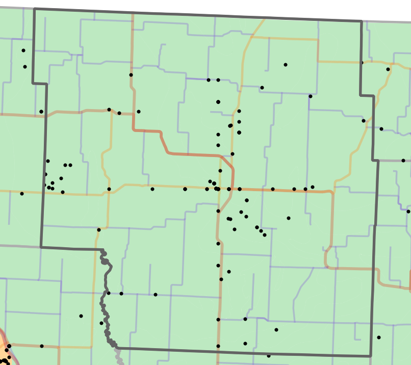
Level I Ecoregion Locality Map

Level I Ecoregion locality map for Nodaway County, Missouri
Map created 15 April 2026.
Level II Ecoregion Locality Map
Level II Ecoregion locality map for Nodaway County, Missouri
Map created 15 April 2026.
Level III Ecoregion Locality Map
Level III Ecoregion locality map for Nodaway County, Missouri
Map created 15 April 2026.
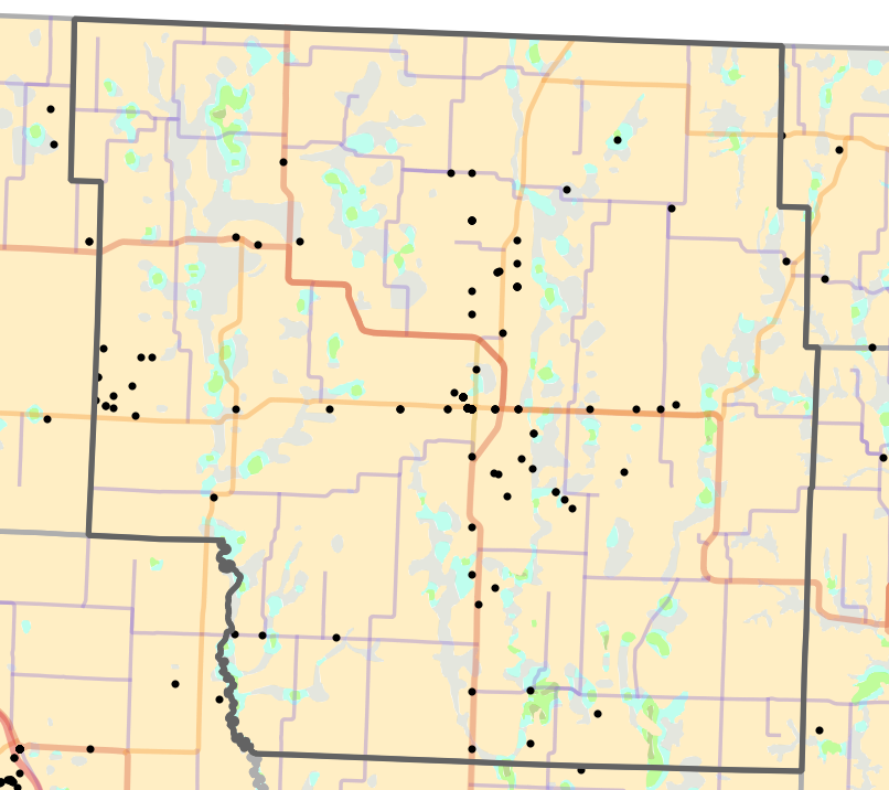
Level IV Ecoregion Locality Map
Level IV Ecoregion locality map for Nodaway County, Missouri
Map created 15 April 2026.
Presettlement Prairie Locality Map
Presettlement Prairie locality map for Nodaway County, Missouri
Map created 15 April 2026.
Historical Vegetation Map
Historical Vegetation map for Nodaway County, Missouri
Map created 15 April 2026.
 | Water |  | Prairie |  | Barrens / Scrub |
 | Forest |  | Woodland |  | Open Woodland |
Geology Locality Map
Geology locality map for Nodaway County, Missouri
Map created 15 April 2026.
 | Alluvium |  | Sandstone |  | Dolomite |  | Limestone |
 | Clay |  | Sandstone / Limestone |  | Dolomite / Limestone |  | Limestone / Sandstone |
 | Igneous |  | Sandstone / Dolomite |  | Dolomite / Shale |  | Limestone / Shale |
 | Limestone / Sandstone / Shale |
Species List
Salamanders (Caudata)
- Ambystoma texanum (Matthes, 1855) - Small-mouthed Salamander
- Ambystoma tigrinum (Green, 1825) - Eastern Tiger Salamander
Frogs (Anura)
- Anaxyrus americanus (Holbrook, 1836) - American Toad
- Anaxyrus woodhousii (Girard, 1854) - Rocky Mountain Toad
- Acris blanchardi Harper, 1947 - Blanchard's Cricket Frog
- Dryophytes versicolor (LeConte, 1825) - Gray Treefrog
- Pseudacris maculata (Agassiz, 1850) - Boreal Chorus Frog
- Lithobates blairi (Mecham, Littlejohn, Oldham, Brown, and Brown, 1973) - Plains Leopard Frog
- Lithobates catesbeianus (Shaw, 1802) - North American Bullfrog
Lizards (Squamata, "Lizards")
- Plestiodon septentrionalis Baird, 1859 - Prairie Skink
- Ophisaurus attenuatus Baird in Cope, 1880 - Western Slender Glass Lizard
Snakes (Squamata, "Snakes")
- Coluber constrictor Linnaeus, 1758 - North American Racer
- Lampropeltis calligaster (Harlan, 1827) - Prairie Kingsnake
- Lampropeltis holbrooki Stejneger, 1902 - Speckled Kingsnake
- Pantherophis obsoletus (Say in James, 1822) - Western Ratsnake
- Pituophis catenifer (Blainville, 1835) - Bullsnake
- Carphophis vermis (Kennicott, 1859) - Western Wormsnake
- Diadophis punctatus (Linnaeus, 1766) - Ring-necked Snake
- Nerodia rhombifer (Hallowell, 1852) - Northern Diamond-backed Watersnake
- Nerodia sipedon (Linnaeus, 1758) - Common Watersnake
- Regina grahamii Baird and Girard, 1853 - Graham's Crawfish Snake
- Storeria dekayi (Holbrook, 1839) - DeKay's Brownsnake
- Thamnophis proximus (Say in James, 1822) - Orange-striped Ribbonsnake
- Thamnophis radix (Baird and Girard, 1853) - Plains Gartersnake
- Thamnophis sirtalis (Linnaeus, 1758) - Common Gartersnake
- Tropidoclonion lineatum (Hallowell, 1856) - Lined Snake
- Sistrurus tergeminus (Say in James, 1822) - Prairie Massasauga
Turtles (Testudines)
- Chelydra serpentina (Linnaeus, 1758) - North American Snapping Turtle
Collection Summary
Nodaway County has a total of 181 valid, non-duplicated collections representing 28 species and 91 localities. There are a total of 15 collectors and 41 collection dates for the county. This results in a total of 51 expeditions for the county, a measure of unique date / collector(s) combinations. The county's earliest collection year is 1905 and its most recent collection year is 2019. The earliest and latest collection dates (independent of earliest and most recent collection years) are March 26 and October 8, respectively. If you have a new record to report for Nodaway County, read the New Records section of the FAQ.
Collection Summary by Species

Potential Species Records
| Likelihood | Species | Common Name | Rationale | Ecoregion / Watershed | |
|---|---|---|---|---|---|
 | 4 | Apalone spinifera | Northern Spiny Softshell | Same watershed, within 10 miles | Tarkio-Wolf |
| 4 | Apalone spinifera | Northern Spiny Softshell | Same watershed, within 10 miles | Upper Grand |
| 4 | Dryophytes chrysoscelis | Cope's Gray Treefrog | Same Level IV ecoregion, within 10 miles | Loess Flats and Till Plains |
| 4 | Heterodon platirhinos | Eastern Hog-nosed Snake | Same Level IV ecoregion, within 10 miles | Loess Flats and Till Plains |
| 4 | Pantherophis ramspotti | Western Foxsnake | Same Level IV ecoregion, within 10 miles | Steeply Rolling Loess Prairies |
| 5 | Chrysemys picta | Western Painted Turtle | Same Level III ecoregion, within 10 miles | Western Corn Belt Plains |
 | 6 | Agkistrodon contortrix | Eastern Copperhead | Same Level IV ecoregion, within 20 miles | Loess Flats and Till Plains |
| 6 | Agkistrodon contortrix | Eastern Copperhead | Same Level IV ecoregion, within 20 miles | Rolling Loess Prairies |
| 6 | Anaxyrus cognatus | Great Plains Toad | Same Level IV ecoregion, within 20 miles | Steeply Rolling Loess Prairies |
| 6 | Anaxyrus cognatus | Great Plains Toad | Same Level IV ecoregion, within 20 miles | Rolling Loess Prairies |
| 6 | Aspidoscelis sexlineatus | Prairie Racerunner | Same Level IV ecoregion, within 20 miles | Rolling Loess Prairies |
| 6 | Crotalus horridus | Timber Rattlesnake | Same Level IV ecoregion, within 20 miles | Rolling Loess Prairies |
| 6 | Crotalus horridus | Timber Rattlesnake | Same Level IV ecoregion, within 20 miles | Loess Flats and Till Plains |
| 6 | Gastrophryne olivacea | Western Narrow-mouthed Toad | Same Level IV ecoregion, within 20 miles | Rolling Loess Prairies |
| 6 | Graptemys pseudogeographica | False Map Turtle | Same watershed, within 20 miles | Tarkio-Wolf |
| 6 | Lampropeltis triangulum | Eastern Milksnake | Same Level IV ecoregion, within 20 miles | Loess Flats and Till Plains |
| 6 | Lampropeltis triangulum | Eastern Milksnake | Same Level IV ecoregion, within 20 miles | Rolling Loess Prairies |
| 6 | Pantherophis emoryi | Great Plains Ratsnake | Same Level IV ecoregion, within 20 miles | Steeply Rolling Loess Prairies |
| 6 | Plestiodon fasciatus | Common Five-lined Skink | Same Level IV ecoregion, within 20 miles | Rolling Loess Prairies |
| 6 | Plestiodon fasciatus | Common Five-lined Skink | Same Level IV ecoregion, within 20 miles | Loess Flats and Till Plains |
| 6 | Pseudacris crucifer | Spring Peeper | Same Level IV ecoregion, within 20 miles | Loess Flats and Till Plains |
| 6 | Spea bombifrons | Plains Spadefoot | Same Level IV ecoregion, within 20 miles | Rolling Loess Prairies |
| 6 | Spea bombifrons | Plains Spadefoot | Same Level IV ecoregion, within 20 miles | Steeply Rolling Loess Prairies |
| 6 | Terrapene ornata | Ornate Box Turtle | Same Level IV ecoregion, within 20 miles | Steeply Rolling Loess Prairies |
| 6 | Trachemys scripta | Red-eared Slider | Same Level IV ecoregion, within 20 miles | Rolling Loess Prairies |
| 6 | Virginia valeriae | Western Smooth Earthsnake | Same Level IV ecoregion, within 20 miles | Loess Flats and Till Plains |
| 7 | Emydoidea blandingii | Blanding's Turtle | Same Level III ecoregion, within 20 miles | Western Corn Belt Plains |
| 7 | Heterodon nasicus | Western Hog-nosed Snake | Same Level III ecoregion, within 20 miles | Western Corn Belt Plains |
| 7 | Lithobates pipiens | Northern Leopard Frog | Same Level III ecoregion, within 20 miles | Western Corn Belt Plains |
 | 8 | Plestiodon obsoletus | Great Plains Skink | Same Level IV ecoregion, within 30 miles | Rolling Loess Prairies |
| 8 | Terrapene triunguis | Three-toed Box Turtle | Same Level IV ecoregion, within 30 miles | Loess Flats and Till Plains |
| 10 | Apalone mutica | Midland Smooth Softshell | Adjacent county, same watershed | Upper Grand |
Checklist
All MOHAP publications are released in portable document format (PDF), an ISO standard. You must download and install a reader (click icon below) to view these documents. A state checklist, including all counties, is available on the publications page.

 Daniel, R.E., B.S. Edmond, and J.T. Briggler. 2026. Checklist of Nodaway County Missouri Amphibians and Reptiles for 2025. <http://atlas.moherp.org/county/Nodaway>
- Daniel, R.E., B.S. Edmond, and J.T. Briggler. 2026. Checklist of Nodaway County Missouri Amphibians and Reptiles for 2025. <http://atlas.moherp.org/county/Nodaway> (with common names)