Maps
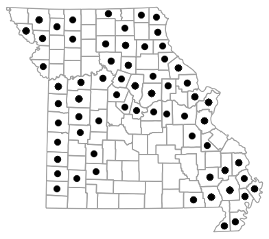
Locality Map

Locality map for Ambystoma texanum (Small-mouthed Salamander).
Map created 15 April 2026.
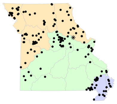
County Map
County map for Ambystoma texanum (Small-mouthed Salamander).
Map created 15 April 2026.
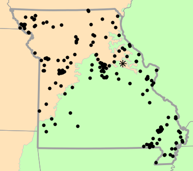
Historical Locality Map

Historical locality map for Ambystoma texanum (Small-mouthed Salamander). Black circles (  ) represent records after 1986, blue squares (
  ) represent records between 1966 and 1986, orange triangles (
  ) represent records prior to 1966. Note that more recent records might conceal underlying older records.
Map created 15 April 2026.
Historical County Map

Historical county map for Ambystoma texanum (Small-mouthed Salamander). Black circles ( ) represent records after 1986, blue squares ( ) represent records between 1966 and 1986, orange triangles ( ) represent records prior to 1966. Note that only the most recent county record for each county is shown.
Map created 15 April 2026.
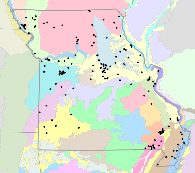
Ecological Drainage Locality Map
Ecological Drainage Units locality map for Ambystoma texanum (Small-mouthed Salamander).
Map created 15 April 2026.
Natural Divisions Locality Map

Natural Divisions and Sections locality map for Ambystoma texanum (Small-mouthed Salamander).
Map created 15 April 2026.
Major Watersheds Locality Map

Major Watersheds locality map for Ambystoma texanum (Small-mouthed Salamander).
Map created 15 April 2026.
Level I Ecoregion Locality Map
Level I Ecoregion locality map for Ambystoma texanum (Small-mouthed Salamander).
Map created 15 April 2026.
Level II Ecoregion Locality Map

Level II Ecoregion locality map for Ambystoma texanum (Small-mouthed Salamander).
Map created 15 April 2026.
Level III Ecoregion Locality Map

Level III Ecoregion locality map for Ambystoma texanum (Small-mouthed Salamander).
Map created 15 April 2026.
Level IV Ecoregion Locality Map
Level IV Ecoregion locality map for Ambystoma texanum (Small-mouthed Salamander).
Map created 15 April 2026.
Native Status
Ambystoma texanum (Small-mouthed Salamander) is native to Missouri.
Collection Summary
Ambystoma texanum (Small-mouthed Salamander) has a total of 453 valid, non-duplicated collections representing 64 counties and 186 localities. There are a total of 123 collectors and 194 collection dates for the species. This results in a total of 213 expeditions for the species, a measure of unique date / collector(s) combinations. The earliest collection year for the species in Missouri is 1893 and its most recent collection year is 2025. The earliest and latest collection dates (independent of earliest and most recent collection years) are January 15 and November 28, respectively. If you have a new record to report, read the New Records section of the FAQ.
Collection Summary by County
| County | Localities | Collections | Collectors | Dates | Expeditions | Earliest Year | Latest Year | |
|---|---|---|---|---|---|---|---|---|
 | Adair | 1 | 1 | 1 | 1 | 1 | 2019 | 2019 |
| Andrew | 2 | 3 | 2 | 2 | 2 | 1968 | 1977 |
| Audrain | 1 | 2 | 2 | 1 | 1 | 1997 | 1997 |
| Barton | 2 | 2 | 4 | 2 | 2 | 1983 | 2012 |
| Bates | 1 | 2 | 1 | 1 | 1 | 1963 | 1963 |
| Benton | 1 | 1 | 2 | 1 | 1 | ||
| Bollinger | 3 | 11 | 4 | 7 | 7 | 1962 | 1974 |
| Boone | 12 | 16 | 9 | 14 | 14 | 1911 | 2025 |
| Butler | 10 | 17 | 9 | 8 | 9 | 1906 | 1970 |
| Callaway | 10 | 27 | 11 | 9 | 10 | 1948 | 2013 |
| Cape Girardeau | 3 | 7 | 4 | 4 | 4 | 1962 | 1995 |
| Cass | 2 | 3 | 2 | 2 | 2 | 1964 | 1993 |
| Chariton | 2 | 4 | 3 | 2 | 2 | 1941 | 1941 |
| Clark | 1 | 1 | 2 | 1 | 1 | 2019 | 2019 |
| Cole | 1 | 1 | 1 | 1 | 1 | 1983 | 1983 |
| Cooper | 1 | 1 | 1 | 1 | 1 | 2000 | 2000 |
| Daviess | 1 | 1 | 1 | 1 | 1 | 1976 | 1976 |
| Dunklin | 3 | 8 | 3 | 4 | 4 | 1962 | 1964 |
| Franklin | 1 | 1 | 1 | 1 | 1 | 1971 | 1971 |
| Gasconade | 1 | 1 | 1 | 1 | 1 | 2015 | 2015 |
| Gentry | 2 | 3 | 1 | 3 | 3 | 2001 | 2001 |
| Greene | 1 | 1 | 1 | 1 | 1 | 1993 | 1993 |
| Harrison | 1 | 1 | 1 | 1 | 1 | 2002 | 2002 |
| Henry | 2 | 7 | 1 | 2 | 2 | 1938 | 1938 |
| Holt | 13 | 31 | 3 | 9 | 9 | 1966 | 1980 |
| Howard | 1 | 2 | 3 | 1 | 1 | 1979 | 1979 |
| Jackson | 6 | 9 | 2 | 5 | 5 | 1937 | 1978 |
| Jasper | 1 | 1 | 1 | 1 | 1 | 2020 | 2020 |
| Jefferson | 3 | 6 | 5 | 4 | 4 | 1903 | 2018 |
| Johnson | 13 | 19 | 17 | 14 | 18 | 1909 | 1997 |
| Lafayette | 3 | 3 | 3 | 3 | 3 | 1960 | 1993 |
| Lawrence | 1 | 1 | 1 | 1 | 1 | 2004 | 2004 |
| Lewis | 2 | 2 | 2 | 2 | 2 | 1996 | 2008 |
| Lincoln | 1 | 2 | 1 | 2 | 2 | 1999 | 2013 |
| Linn | 2 | 3 | 4 | 2 | 2 | 1980 | 1984 |
| Macon | 3 | 5 | 3 | 4 | 4 | 1967 | 2019 |
| Marion | 1 | 1 | 1 | 1 | 1 | 2001 | 2001 |
| Mississippi | 4 | 14 | 6 | 5 | 5 | 1962 | 1988 |
| Moniteau | 1 | 1 | 1 | 1 | 1 | 2015 | 2015 |
| Montgomery | 1 | 3 | 2 | 2 | 2 | 1901 | 1901 |
| New Madrid | 3 | 18 | 3 | 4 | 4 | 1932 | 1962 |
| Newton | 1 | 1 | 2 | 1 | 1 | 2021 | 2021 |
| Nodaway | 6 | 8 | 6 | 6 | 6 | 1967 | 2015 |
| Osage | 1 | 1 | 1 | 1 | 1 | 1976 | 1976 |
| Pemiscot | 2 | 2 | 2 | 2 | 2 | 1938 | 1962 |
| Pike | 6 | 6 | 2 | 6 | 6 | 1938 | 1999 |
| Platte | 1 | 1 | 1 | 1 | 1 | 1992 | 1992 |
| Polk | 1 | 1 | 1 | 1 | 1 | 1999 | 1999 |
| Putnam | 2 | 2 | 1 | 1 | 1 | 1992 | 1992 |
| Ralls | 1 | 2 | 1 | 1 | 1 | 1997 | 1997 |
| Randolph | 3 | 6 | 3 | 5 | 5 | 1994 | 2001 |
| Ripley | 2 | 29 | 2 | 2 | 2 | 1964 | 1966 |
| Saint Charles | 2 | 7 | 4 | 5 | 6 | 1900 | 1934 |
| Saint Clair | 1 | 1 | 1 | 1 | 1 | 1938 | 1938 |
| Saint Francois | 1 | 1 | 1 | 1 | 1 | 1995 | 1995 |
| Saint Louis | 9 | 14 | 10 | 9 | 11 | 1893 | 2009 |
| Saline | 2 | 2 | 2 | 2 | 2 | 1998 | 2022 |
| Scotland | 1 | 2 | 2 | 2 | 2 | 2003 | 2003 |
| Scott | 1 | 1 | 1 | 1 | 1 | 1962 | 1962 |
| Shelby | 1 | 2 | 1 | 1 | 1 | 1998 | 1998 |
| Stoddard | 12 | 114 | 23 | 31 | 36 | 1899 | 2022 |
| Vernon | 1 | 1 | 1 | 1 | 1 | 2012 | 2012 |
| Washington | 1 | 1 | 1 | 1 | 1 | 1942 | 1942 |
| Wayne | 3 | 4 | 5 | 4 | 4 | 1953 | 2000 |
Potential County Records
| Likelihood | County | Rationale | Ecoregion / Watershed | |
|---|---|---|---|---|
 | 2 | Carroll | Same Level IV ecoregion, within 5 miles | Missouri Alluvial Plain |
| 2 | Carroll | Same Level IV ecoregion, within 5 miles | Rolling Loess Prairies |
| 2 | Carroll | Same Level IV ecoregion, within 5 miles | Loess Flats and Till Plains |
| 2 | Clay | Same Level IV ecoregion, within 5 miles | Missouri Alluvial Plain |
| 2 | Dade | Same Level IV ecoregion, within 5 miles | Springfield Plateau |
| 2 | De Kalb | Same Level IV ecoregion, within 5 miles | Loess Flats and Till Plains |
| 2 | Grundy | Same Level IV ecoregion, within 5 miles | Loess Flats and Till Plains |
| 2 | Knox | Same Level IV ecoregion, within 5 miles | Loess Flats and Till Plains |
| 2 | Livingston | Same Level IV ecoregion, within 5 miles | Loess Flats and Till Plains |
| 2 | Pettis | Same Level IV ecoregion, within 5 miles | Wooded Osage Plains |
| 2 | Sainte Genevieve | Same Level IV ecoregion, within 5 miles | St. Francois Knobs and Basins |
| 2 | Schuyler | Same Level IV ecoregion, within 5 miles | Loess Flats and Till Plains |
| 3 | Atchison | Same Level III ecoregion, within 5 miles | Western Corn Belt Plains |
| 4 | Buchanan | Same Level IV ecoregion, within 10 miles | Rolling Loess Prairies |
| 4 | Christian | Same Level IV ecoregion, within 10 miles | Springfield Plateau |
| 4 | Hickory | Same Level IV ecoregion, within 10 miles | Osage/Gasconade Hills |
| 4 | Mercer | Same Level IV ecoregion, within 10 miles | Loess Flats and Till Plains |
| 4 | Monroe | Same Level IV ecoregion, within 10 miles | Claypan Prairie |
| 4 | Ray | Same Level IV ecoregion, within 10 miles | Missouri Alluvial Plain |
| 4 | Ray | Same Level IV ecoregion, within 10 miles | Rolling Loess Prairies |
| 4 | Webster | Same Level IV ecoregion, within 10 miles | Springfield Plateau |
 | 6 | Barry | Same Level IV ecoregion, within 20 miles | Springfield Plateau |
| 6 | Caldwell | Same Level IV ecoregion, within 20 miles | Loess Flats and Till Plains |
| 6 | Camden | Same Level IV ecoregion, within 20 miles | Osage/Gasconade Hills |
| 6 | Cedar | Same Level IV ecoregion, within 20 miles | Osage/Gasconade Hills |
| 6 | Cedar | Same Level IV ecoregion, within 20 miles | Springfield Plateau |
| 6 | Cedar | Same Level IV ecoregion, within 20 miles | Cherokee Plains |
| 6 | Clinton | Same Level IV ecoregion, within 20 miles | Rolling Loess Prairies |
| 6 | Crawford | Same Level IV ecoregion, within 20 miles | Central Plateau |
| 6 | Dallas | Same Level IV ecoregion, within 20 miles | Central Plateau |
| 6 | Douglas | Same Level IV ecoregion, within 20 miles | Springfield Plateau |
| 6 | Iron | Same Level IV ecoregion, within 20 miles | St. Francois Knobs and Basins |
| 6 | Madison | Same Level IV ecoregion, within 20 miles | St. Francois Knobs and Basins |
| 6 | Maries | Same Level IV ecoregion, within 20 miles | Osage/Gasconade Hills |
| 6 | McDonald | Same Level IV ecoregion, within 20 miles | Springfield Plateau |
| 6 | Miller | Same Level IV ecoregion, within 20 miles | River Hills |
| 6 | Morgan | Same Level IV ecoregion, within 20 miles | Osage/Gasconade Hills |
| 6 | Morgan | Same Level IV ecoregion, within 20 miles | Prairie Ozark Border |
| 6 | Perry | Same Level IV ecoregion, within 20 miles | Middle Mississippi Alluvial Plain |
| 6 | Perry | Same Level IV ecoregion, within 20 miles | River Hills |
| 6 | Stone | Same Level IV ecoregion, within 20 miles | Springfield Plateau |
| 6 | Sullivan | Same Level IV ecoregion, within 20 miles | Loess Flats and Till Plains |
| 6 | Warren | Same Level IV ecoregion, within 20 miles | River Hills |
| 6 | Worth | Same Level IV ecoregion, within 20 miles | Loess Flats and Till Plains |
| 6 | Worth | Same Level IV ecoregion, within 20 miles | Rolling Loess Prairies |
 | 8 | Phelps | Same Level IV ecoregion, within 30 miles | Osage/Gasconade Hills |
| 8 | Phelps | Same Level IV ecoregion, within 30 miles | Central Plateau |
| 8 | Reynolds | Same Level IV ecoregion, within 30 miles | St. Francois Knobs and Basins |
| 8 | Wright | Same Level IV ecoregion, within 30 miles | Springfield Plateau |
| 9 | Laclede | Same Level III ecoregion, within 30 miles | Ozark Highlands |
| 9 | Taney | Same Level III ecoregion, within 30 miles | Ozark Highlands |
| 10 | Oregon | Same Level IV ecoregion, adjacent county | Central Plateau |
| 11 | Carter | Same Level III ecoregion, adjacent county | Ozark Highlands |
Linnaean Classification
- Kingdom:
- Animalia - Animals
- Phylum:
- Chordata - Chordates
- Subphylum:
- Vertebrata - Vertebrates
- Class:
- Amphibia Gray, 1825 - Amphibians
- Order:
- Caudata Scopoli, 1777 - Salamanders
- Family:
- Ambystomatidae Gray, 1850 - Mole Salamanders
- Genus:
- Ambystoma Tschudi, 1838 - Mole Salamanders
- Species:
- Ambystoma texanum (Matthes, 1855) - Small-mouthed Salamander
Recent Taxonomic Synonyms
(none)