Maps
Locality Map

Locality map for Storeria occipitomaculata (Red-bellied Snake).
Map created 15 April 2026.
County Map

County map for Storeria occipitomaculata (Red-bellied Snake).
Map created 15 April 2026.
Historical Locality Map
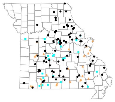
Historical locality map for Storeria occipitomaculata (Red-bellied Snake). Black circles (  ) represent records after 1986, blue squares (
  ) represent records between 1966 and 1986, orange triangles (
  ) represent records prior to 1966. Note that more recent records might conceal underlying older records.
Map created 15 April 2026.
Historical County Map
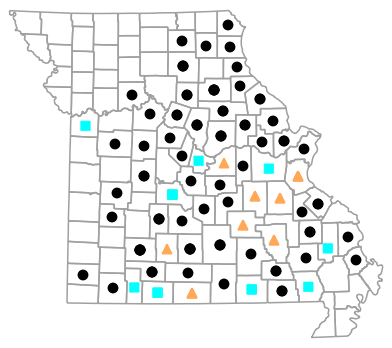
Historical county map for Storeria occipitomaculata (Red-bellied Snake). Black circles ( ) represent records after 1986, blue squares ( ) represent records between 1966 and 1986, orange triangles ( ) represent records prior to 1966. Note that only the most recent county record for each county is shown.
Map created 15 April 2026.
Ecological Drainage Locality Map
Ecological Drainage Units locality map for Storeria occipitomaculata (Red-bellied Snake).
Map created 15 April 2026.
Natural Divisions Locality Map

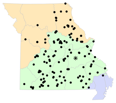
Natural Divisions and Sections locality map for Storeria occipitomaculata (Red-bellied Snake).
Map created 15 April 2026.
Major Watersheds Locality Map

Major Watersheds locality map for Storeria occipitomaculata (Red-bellied Snake).
Map created 15 April 2026.
Level I Ecoregion Locality Map

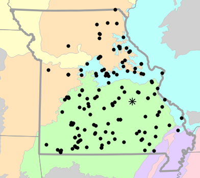
Level I Ecoregion locality map for Storeria occipitomaculata (Red-bellied Snake).
Map created 15 April 2026.
Level II Ecoregion Locality Map

Level II Ecoregion locality map for Storeria occipitomaculata (Red-bellied Snake).
Map created 15 April 2026.
Level III Ecoregion Locality Map
Level III Ecoregion locality map for Storeria occipitomaculata (Red-bellied Snake).
Map created 15 April 2026.
Level IV Ecoregion Locality Map

Level IV Ecoregion locality map for Storeria occipitomaculata (Red-bellied Snake).
Map created 15 April 2026.
Native Status
Storeria occipitomaculata (Red-bellied Snake) is native to Missouri.
Collection Summary
Storeria occipitomaculata (Red-bellied Snake) has a total of 206 valid, non-duplicated collections representing 70 counties and 157 localities. There are a total of 87 collectors and 152 collection dates for the species. This results in a total of 157 expeditions for the species, a measure of unique date / collector(s) combinations. The earliest collection year for the species in Missouri is 1889 and its most recent collection year is 2025. The earliest and latest collection dates (independent of earliest and most recent collection years) are February 26 and November 13, respectively. If you have a new record to report, read the New Records section of the FAQ.
Collection Summary by County
| County | Localities | Collections | Collectors | Dates | Expeditions | Earliest Year | Latest Year | |
|---|---|---|---|---|---|---|---|---|
 | Adair | 1 | 1 | 1 | 1 | 1 | 2012 | 2012 |
| Audrain | 2 | 2 | 1 | 2 | 2 | 1999 | 1999 |
| Barry | 4 | 4 | 5 | 4 | 4 | 1930 | 2007 |
| Benton | 3 | 3 | 2 | 2 | 2 | 1962 | 2002 |
| Bollinger | 1 | 2 | 1 | 1 | 1 | 1971 | 1971 |
| Boone | 15 | 30 | 4 | 18 | 20 | 1978 | 2025 |
| Butler | 1 | 1 | 3 | 1 | 1 | 1970 | 1970 |
| Callaway | 4 | 4 | 6 | 4 | 4 | 2001 | 2024 |
| Camden | 3 | 3 | 2 | 3 | 3 | 1966 | 1977 |
| Cape Girardeau | 1 | 1 | 1 | 1 | 1 | 1996 | 1996 |
| Carroll | 1 | 1 | 1 | 1 | 1 | 2020 | 2020 |
| Carter | 4 | 4 | 8 | 4 | 4 | 1930 | 2002 |
| Cedar | 1 | 1 | 1 | 1 | 1 | 2022 | 2022 |
| Christian | 4 | 4 | 6 | 4 | 4 | 1973 | 2022 |
| Clark | 1 | 1 | 1 | 1 | 1 | 2010 | 2010 |
| Cole | 1 | 1 | 1 | 1 | 1 | 1980 | 1980 |
| Cooper | 1 | 1 | 1 | 1 | 1 | 2001 | 2001 |
| Crawford | 2 | 3 | 3 | 3 | 3 | 1902 | 2024 |
| Dallas | 3 | 3 | 5 | 2 | 2 | 2000 | 2008 |
| Dent | 1 | 2 | 2 | 2 | 2 | 1909 | 1909 |
| Douglas | 2 | 2 | 2 | 2 | 2 | 1972 | 2002 |
| Franklin | 2 | 2 | 2 | 2 | 2 | 1941 | 1971 |
| Gasconade | 1 | 1 | 1 | 1 | 1 | 2006 | 2006 |
| Greene | 9 | 9 | 6 | 9 | 9 | 1969 | 2024 |
| Hickory | 1 | 1 | 4 | 1 | 1 | 2024 | 2024 |
| Howard | 2 | 2 | 1 | 2 | 2 | 2001 | 2006 |
| Howell | 1 | 1 | 1 | 1 | 1 | 2002 | 2002 |
| Jackson | 1 | 1 | 1 | 1 | 1 | 1984 | 1984 |
| Jefferson | 3 | 4 | 2 | 2 | 2 | 1897 | 1897 |
| Johnson | 1 | 3 | 2 | 3 | 3 | 1960 | 2008 |
| Knox | 1 | 1 | 1 | 1 | 1 | 2011 | 2011 |
| Laclede | 1 | 1 | 2 | 1 | 1 | 2000 | 2000 |
| Lewis | 1 | 1 | 1 | 1 | 1 | 1996 | 1996 |
| Lincoln | 1 | 3 | 1 | 2 | 2 | 1978 | 2009 |
| Macon | 3 | 3 | 6 | 3 | 3 | 1997 | 2021 |
| Madison | 2 | 2 | 1 | 1 | 1 | 2015 | 2015 |
| Maries | 1 | 1 | 1 | 1 | 1 | 2000 | 2000 |
| Marion | 1 | 1 | 1 | 1 | 1 | 2002 | 2002 |
| Miller | 2 | 2 | 5 | 2 | 2 | 1967 | 2006 |
| Moniteau | 1 | 1 | 1 | 1 | 1 | 1998 | 1998 |
| Monroe | 4 | 4 | 5 | 4 | 4 | 1988 | 2021 |
| Montgomery | 3 | 5 | 5 | 4 | 4 | 1906 | 2004 |
| Newton | 1 | 1 | 1 | 1 | 1 | 1993 | 1993 |
| Oregon | 3 | 7 | 3 | 5 | 5 | 1900 | 1975 |
| Osage | 1 | 1 | 1 | 1 | 1 | 1936 | 1936 |
| Ozark | 2 | 5 | 3 | 3 | 3 | 1902 | 1961 |
| Pettis | 2 | 2 | 2 | 2 | 2 | 1967 | 2014 |
| Phelps | 2 | 2 | 2 | 2 | 2 | 1978 | 1993 |
| Pike | 2 | 3 | 1 | 2 | 2 | 1992 | 2017 |
| Pulaski | 2 | 2 | 3 | 2 | 2 | 1966 | 2016 |
| Ralls | 1 | 1 | 1 | 1 | 1 | 2005 | 2005 |
| Randolph | 2 | 2 | 1 | 2 | 2 | 2001 | 2004 |
| Reynolds | 2 | 2 | 2 | 2 | 2 | 1963 | 1963 |
| Ripley | 2 | 2 | 2 | 2 | 2 | 2009 | 2009 |
| Saint Charles | 2 | 2 | 1 | 2 | 2 | 2010 | 2013 |
| Saint Clair | 6 | 16 | 8 | 7 | 7 | 1936 | 2007 |
| Sainte Genevieve | 2 | 2 | 5 | 2 | 2 | 2004 | 2010 |
| Saint Francois | 1 | 1 | 1 | 1 | 1 | 2020 | 2020 |
| Saint Louis | 3 | 4 | 4 | 3 | 4 | 1889 | 2010 |
| Saline | 1 | 1 | 2 | 1 | 1 | 2012 | 2012 |
| Scott | 1 | 1 | 1 | 1 | 1 | 2001 | 2001 |
| Shannon | 1 | 1 | 1 | 1 | 1 | 1992 | 1992 |
| Stone | 4 | 7 | 4 | 5 | 5 | 1892 | 1973 |
| Taney | 2 | 2 | 2 | 2 | 2 | 1967 | 1974 |
| Texas | 3 | 3 | 2 | 3 | 3 | 2001 | 2004 |
| Warren | 2 | 2 | 2 | 2 | 2 | 1966 | 2009 |
| Washington | 1 | 3 | 1 | 2 | 2 | 1909 | 1909 |
| Wayne | 2 | 2 | 4 | 2 | 2 | 1934 | 2010 |
| Webster | 1 | 1 | 1 | 1 | 1 | 1961 | 1961 |
| Wright | 5 | 5 | 5 | 4 | 4 | 1973 | 2014 |
Potential County Records
| Likelihood | County | Rationale | Ecoregion / Watershed | |
|---|---|---|---|---|
 | 2 | Henry | Same Level IV ecoregion, within 5 miles | Osage/Gasconade Hills |
| 2 | Iron | Same Level IV ecoregion, within 5 miles | St. Francois Knobs and Basins |
| 2 | Livingston | Same Level IV ecoregion, within 5 miles | Loess Flats and Till Plains |
| 2 | McDonald | Same Level IV ecoregion, within 5 miles | Springfield Plateau |
| 2 | Morgan | Same Level IV ecoregion, within 5 miles | Osage/Gasconade Hills |
| 2 | Polk | Same Level IV ecoregion, within 5 miles | Central Plateau |
| 2 | Polk | Same Level IV ecoregion, within 5 miles | Springfield Plateau |
| 2 | Scotland | Same Level IV ecoregion, within 5 miles | Loess Flats and Till Plains |
| 4 | Caldwell | Same Level IV ecoregion, within 10 miles | Loess Flats and Till Plains |
| 4 | Cass | Same Level IV ecoregion, within 10 miles | Wooded Osage Plains |
| 4 | Dade | Same Level IV ecoregion, within 10 miles | Springfield Plateau |
| 4 | Lawrence | Same Level IV ecoregion, within 10 miles | Springfield Plateau |
| 4 | Perry | Same Level IV ecoregion, within 10 miles | River Hills |
| 4 | Shelby | Same Level IV ecoregion, within 10 miles | Claypan Prairie |
| 4 | Stoddard | Same Level IV ecoregion, within 10 miles | St. Francis Lowlands |
 | 6 | Barton | Same Level IV ecoregion, within 20 miles | Springfield Plateau |
| 6 | Chariton | Same Level IV ecoregion, within 20 miles | Loess Flats and Till Plains |
| 6 | Daviess | Same Level IV ecoregion, within 20 miles | Loess Flats and Till Plains |
| 6 | Dunklin | Same Level IV ecoregion, within 20 miles | Western Lowlands Pleistocene Valley Trains |
| 6 | Jasper | Same Level IV ecoregion, within 20 miles | Springfield Plateau |
| 6 | Lafayette | Same Level IV ecoregion, within 20 miles | Wooded Osage Plains |
| 6 | Linn | Same Level IV ecoregion, within 20 miles | Loess Flats and Till Plains |
| 6 | Mississippi | Same Level IV ecoregion, within 20 miles | St. Francis Lowlands |
| 6 | Ray | Same Level IV ecoregion, within 20 miles | Loess Flats and Till Plains |
| 6 | Schuyler | Same Level IV ecoregion, within 20 miles | Claypan Prairie |
| 6 | Schuyler | Same Level IV ecoregion, within 20 miles | Loess Flats and Till Plains |
| 7 | Putnam | Same Level III ecoregion, within 20 miles | Central Irregular Plains |
| 7 | Sullivan | Same Level III ecoregion, within 20 miles | Central Irregular Plains |
 | 8 | Grundy | Same Level IV ecoregion, within 30 miles | Loess Flats and Till Plains |
| 8 | New Madrid | Same Level IV ecoregion, within 30 miles | St. Francis Lowlands |
| 9 | Platte | Same Level III ecoregion, within 30 miles | Central Irregular Plains |
| 10 | Bates | Same Level IV ecoregion, adjacent county | Wooded Osage Plains |
| 10 | Clay | Same Level IV ecoregion, adjacent county | Loess Flats and Till Plains |
| 10 | Vernon | Same Level IV ecoregion, adjacent county | Wooded Osage Plains |
Linnaean Classification
- Kingdom:
- Animalia - Animals
- Phylum:
- Chordata - Chordates
- Subphylum:
- Vertebrata - Vertebrates
- Class:
- Reptilia Laurenti, 1768 - Reptiles
- Order:
- Squamata Oppel, 1811 - Lizards and Snakes
- Family:
- Natricidae Bonaparte, 1838 - Harmless Egg-retaining Snakes
- Genus:
- Storeria Baird and Girard, 1853 - North American Brownsnakes
- Species:
- Storeria occipitomaculata (Storer, 1839) - Red-bellied Snake
Recent Taxonomic Synonyms
(none)