Maps
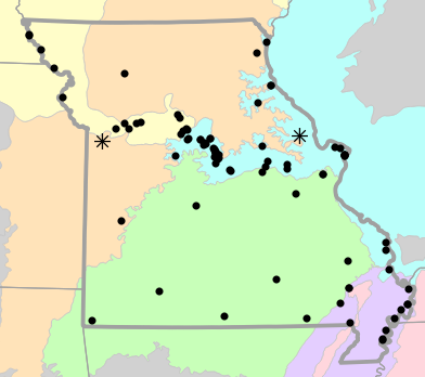
Locality Map

Locality map for Graptemys pseudogeographica (False Map Turtle).
Map created 15 April 2026.
County Map

County map for Graptemys pseudogeographica (False Map Turtle).
Map created 15 April 2026.
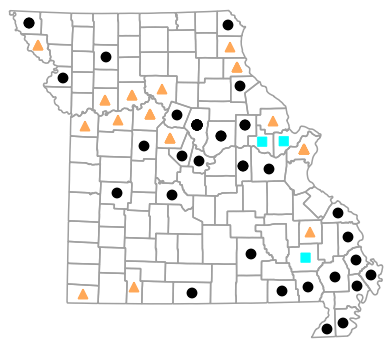
Historical Locality Map

Historical locality map for Graptemys pseudogeographica (False Map Turtle). Black circles (  ) represent records after 1986, blue squares (
  ) represent records between 1966 and 1986, orange triangles (
  ) represent records prior to 1966. Note that more recent records might conceal underlying older records.
Map created 15 April 2026.
Historical County Map
Historical county map for Graptemys pseudogeographica (False Map Turtle). Black circles ( ) represent records after 1986, blue squares ( ) represent records between 1966 and 1986, orange triangles ( ) represent records prior to 1966. Note that only the most recent county record for each county is shown.
Map created 15 April 2026.
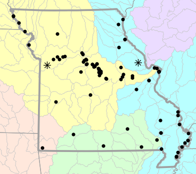
Ecological Drainage Locality Map

Ecological Drainage Units locality map for Graptemys pseudogeographica (False Map Turtle).
Map created 15 April 2026.
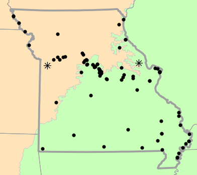
Natural Divisions Locality Map

Natural Divisions and Sections locality map for Graptemys pseudogeographica (False Map Turtle).
Map created 15 April 2026.
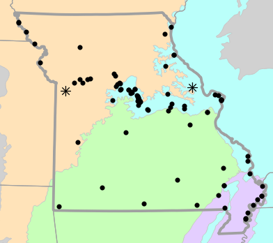
Major Watersheds Locality Map
Major Watersheds locality map for Graptemys pseudogeographica (False Map Turtle).
Map created 15 April 2026.
Level I Ecoregion Locality Map
Level I Ecoregion locality map for Graptemys pseudogeographica (False Map Turtle).
Map created 15 April 2026.
Level II Ecoregion Locality Map
Level II Ecoregion locality map for Graptemys pseudogeographica (False Map Turtle).
Map created 15 April 2026.
Level III Ecoregion Locality Map
Level III Ecoregion locality map for Graptemys pseudogeographica (False Map Turtle).
Map created 15 April 2026.
Level IV Ecoregion Locality Map

Level IV Ecoregion locality map for Graptemys pseudogeographica (False Map Turtle).
Map created 15 April 2026.
Native Status
Graptemys pseudogeographica (False Map Turtle) is native to Missouri.
Collection Summary
Graptemys pseudogeographica (False Map Turtle) has a total of 115 valid, non-duplicated collections representing 46 counties and 86 localities. There are a total of 45 collectors and 59 collection dates for the species. This results in a total of 63 expeditions for the species, a measure of unique date / collector(s) combinations. The earliest collection year for the species in Missouri is 1884 and its most recent collection year is 2024. The earliest and latest collection dates (independent of earliest and most recent collection years) are March 4 and December 10, respectively. If you have a new record to report, read the New Records section of the FAQ.
Collection Summary by County
| County | Localities | Collections | Collectors | Dates | Expeditions | Earliest Year | Latest Year | |
|---|---|---|---|---|---|---|---|---|
 | Atchison | 2 | 2 | 1 | 1 | 1 | 2014 | 2014 |
| Boone | 13 | 18 | 3 | 14 | 14 | 1961 | 2024 |
| Buchanan | 1 | 1 | 1 | 1 | 1 | 2015 | 2015 |
| Butler | 1 | 1 | 1 | 1 | 1 | 2015 | 2015 |
| Callaway | 2 | 2 | 1 | 1 | 1 | 1999 | 1999 |
| Camden | 1 | 1 | 1 | 1 | 1 | 1991 | 1991 |
| Cape Girardeau | 1 | 1 | 1 | 1 | 1 | 2007 | 2007 |
| Carroll | 2 | 2 | 1 | 1 | 1 | ||
| Chariton | 1 | 1 | 1 | 1 | 1 | ||
| Clark | 1 | 2 | 1 | 1 | 1 | 2013 | 2013 |
| Cole | 1 | 1 | 3 | 1 | 1 | 2001 | 2001 |
| Cooper | 3 | 4 | 2 | 2 | 2 | 1946 | 1946 |
| Daviess | 1 | 1 | 1 | 1 | 1 | 2019 | 2019 |
| Dunklin | 1 | 1 | 2 | 1 | 1 | 2009 | 2009 |
| Franklin | 2 | 4 | 2 | 2 | 2 | 1972 | 1988 |
| Gasconade | 2 | 2 | 5 | 2 | 2 | 2006 | 2006 |
| Holt | 2 | 3 | 2 | 2 | 2 | 1959 | 1959 |
| Howard | 5 | 6 | 3 | 2 | 2 | 1999 | 1999 |
| Jackson | 1 | 1 | 1 | 1 | 1 | 1909 | 1909 |
| Lafayette | 1 | 1 | 1 | 1 | 1 | ||
| Lewis | 1 | 1 | 1 | 1 | 1 | 1958 | 1958 |
| Lincoln | 1 | 2 | 1 | 1 | 1 | ||
| Madison | 1 | 1 | 1 | 1 | 1 | ||
| Marion | 2 | 3 | 2 | 3 | 3 | 1958 | 1959 |
| McDonald | 1 | 1 | 1 | 1 | 1 | 1945 | 1945 |
| Mississippi | 3 | 5 | 7 | 4 | 4 | 1934 | 2007 |
| Moniteau | 2 | 3 | 2 | 2 | 2 | 1999 | 1999 |
| Montgomery | 2 | 2 | 4 | 2 | 2 | 2006 | 2023 |
| New Madrid | 1 | 2 | 2 | 1 | 1 | 2006 | 2006 |
| Ozark | 1 | 1 | 2 | 1 | 1 | 2012 | 2012 |
| Pemiscot | 3 | 3 | 3 | 3 | 3 | 1938 | 1994 |
| Perry | 1 | 1 | 1 | 1 | 1 | 2013 | 2013 |
| Pettis | 1 | 1 | 1 | 1 | 1 | 2022 | 2022 |
| Ralls | 1 | 1 | 4 | 1 | 1 | 2006 | 2006 |
| Ray | 2 | 2 | 1 | 1 | 1 | ||
| Ripley | 1 | 1 | 3 | 1 | 1 | 2010 | 2010 |
| Saint Charles | 2 | 3 | 2 | 2 | 2 | 1922 | 1972 |
| Saint Clair | 1 | 1 | 1 | 1 | 1 | 2017 | 2017 |
| Saint Louis | 3 | 12 | 4 | 5 | 6 | 1884 | 1961 |
| Saline | 3 | 3 | 1 | 1 | 1 | ||
| Scott | 1 | 1 | 3 | 1 | 1 | 2002 | 2002 |
| Shannon | 1 | 1 | 1 | 1 | 1 | 2017 | 2017 |
| Stoddard | 1 | 1 | 1 | 1 | 1 | 2001 | 2001 |
| Stone | 1 | 1 | 1 | 1 | 1 | ||
| Warren | 1 | 2 | 1 | 1 | 1 | 1972 | 1972 |
| Wayne | 1 | 1 | 1 | 1 | 1 | 1981 | 1981 |
Potential County Records
| Likelihood | County | Rationale | Ecoregion / Watershed | |
|---|---|---|---|---|
 | 2 | Bollinger | Same watershed, within 5 miles | Lower St. Francis |
| 2 | Bollinger | Same watershed, within 5 miles | Whitewater |
| 2 | Cedar | Same watershed, within 5 miles | Harry S. Truman Reservoir |
| 2 | Christian | Same watershed, within 5 miles | James |
| 2 | Crawford | Same watershed, within 5 miles | Meramec |
| 2 | Jefferson | Same watershed, within 5 miles | Meramec |
| 2 | Monroe | Same watershed, within 5 miles | Salt |
| 2 | Morgan | Same watershed, within 5 miles | Lake of the Ozarks |
| 2 | Osage | Same watershed, within 5 miles | Lower Gasconade |
| 2 | Osage | Same watershed, within 5 miles | Lower Missouri-Moreau |
| 2 | Platte | Same watershed, within 5 miles | Independence-Sugar |
| 2 | Vernon | Same watershed, within 5 miles | Harry S. Truman Reservoir |
| 2 | Washington | Same watershed, within 5 miles | Meramec |
| 4 | Andrew | Same watershed, within 10 miles | Tarkio-Wolf |
| 4 | Audrain | Same watershed, within 10 miles | Lower Missouri |
| 4 | Bates | Same watershed, within 10 miles | Harry S. Truman Reservoir |
| 4 | Caldwell | Same watershed, within 10 miles | Upper Grand |
| 4 | Clay | Same watershed, within 10 miles | Lower Missouri-Crooked |
| 4 | Greene | Same watershed, within 10 miles | James |
| 4 | Grundy | Same watershed, within 10 miles | Upper Grand |
| 4 | Livingston | Same watershed, within 10 miles | Upper Grand |
| 4 | Miller | Same watershed, within 10 miles | Lake of the Ozarks |
 | 6 | Barry | Same watershed, within 20 miles | James |
| 6 | Benton | Same watershed, within 20 miles | Lamine |
| 6 | Benton | Same watershed, within 20 miles | Lake of the Ozarks |
| 6 | Carter | Same watershed, within 20 miles | Upper Black |
| 6 | Carter | Same watershed, within 20 miles | Current |
| 6 | Clinton | Same watershed, within 20 miles | Upper Grand |
| 6 | De Kalb | Same watershed, within 20 miles | Upper Grand |
| 6 | Dent | Same watershed, within 20 miles | Current |
| 6 | Douglas | Same watershed, within 20 miles | North Fork White |
| 6 | Gentry | Same watershed, within 20 miles | Upper Grand |
| 6 | Harrison | Same watershed, within 20 miles | Upper Grand |
| 6 | Henry | Same watershed, within 20 miles | Harry S. Truman Reservoir |
| 6 | Hickory | Same watershed, within 20 miles | Lake of the Ozarks |
| 6 | Howell | Same watershed, within 20 miles | North Fork White |
| 6 | Howell | Same watershed, within 20 miles | Current |
| 6 | Johnson | Same watershed, within 20 miles | Lower Missouri-Crooked |
| 6 | Laclede | Same watershed, within 20 miles | Lake of the Ozarks |
| 6 | Lawrence | Same watershed, within 20 miles | James |
| 6 | Maries | Same watershed, within 20 miles | Lower Gasconade |
| 6 | Newton | Same watershed, within 20 miles | Elk |
| 6 | Nodaway | Same watershed, within 20 miles | Tarkio-Wolf |
| 6 | Oregon | Same watershed, within 20 miles | Current |
| 6 | Pike | Same watershed, within 20 miles | The Sny |
| 6 | Pike | Same watershed, within 20 miles | Salt |
| 6 | Randolph | Same watershed, within 20 miles | Lower Missouri-Moreau |
| 6 | Reynolds | Same watershed, within 20 miles | Current |
| 6 | Scotland | Same watershed, within 20 miles | Bear-Wyaconda |
| 6 | Shelby | Same watershed, within 20 miles | Salt |
| 6 | Texas | Same watershed, within 20 miles | Current |
 | 8 | Barton | Same watershed, within 30 miles | Harry S. Truman Reservoir |
| 8 | Cass | Same watershed, within 30 miles | Lower Missouri-Crooked |
| 8 | Phelps | Same watershed, within 30 miles | Lower Gasconade |
| 8 | Phelps | Same watershed, within 30 miles | Meramec |
| 8 | Polk | Same watershed, within 30 miles | Harry S. Truman Reservoir |
| 8 | Pulaski | Same watershed, within 30 miles | Lake of the Ozarks |
| 8 | Sainte Genevieve | Same watershed, within 30 miles | Upper Mississippi-Cape Girardeau |
| 8 | Sainte Genevieve | Same watershed, within 30 miles | Whitewater |
| 8 | Saint Francois | Same watershed, within 30 miles | Whitewater |
| 8 | Webster | Same watershed, within 30 miles | James |
| 8 | Wright | Same watershed, within 30 miles | North Fork White |
| 10 | Iron | Adjacent county, same watershed | Upper Black |
| 10 | Iron | Adjacent county, same watershed | Meramec |
| 10 | Knox | Adjacent county, same watershed | The Sny |
Linnaean Classification
- Kingdom:
- Animalia - Animals
- Phylum:
- Chordata - Chordates
- Subphylum:
- Vertebrata - Vertebrates
- Class:
- Reptilia Laurenti, 1768 - Reptiles
- Order:
- Testudines Batsch, 1788 - Turtles
- Family:
- Emydidae Gray, 1825 - Box and Basking Turtles
- Genus:
- Graptemys Agassiz, 1857 - Map Turtles
- Species:
- Graptemys pseudogeographica (Gray, 1831) - False Map Turtle
Recent Taxonomic Synonyms
- Graptemys kohnii