Maps
Locality Map
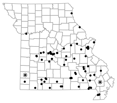
Locality map for Necturus maculosus (Mudpuppy).
Map created 15 April 2026.
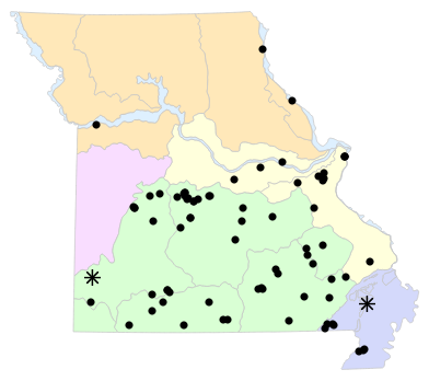
County Map

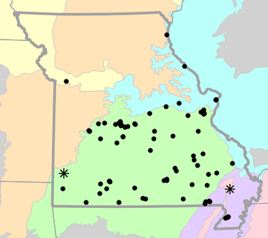
County map for Necturus maculosus (Mudpuppy).
Map created 15 April 2026.
Historical Locality Map

Historical locality map for Necturus maculosus (Mudpuppy). Black circles (  ) represent records after 1986, blue squares (
  ) represent records between 1966 and 1986, orange triangles (
  ) represent records prior to 1966. Note that more recent records might conceal underlying older records.
Map created 15 April 2026.
Historical County Map

Historical county map for Necturus maculosus (Mudpuppy). Black circles ( ) represent records after 1986, blue squares ( ) represent records between 1966 and 1986, orange triangles ( ) represent records prior to 1966. Note that only the most recent county record for each county is shown.
Map created 15 April 2026.
Ecological Drainage Locality Map

Ecological Drainage Units locality map for Necturus maculosus (Mudpuppy).
Map created 15 April 2026.
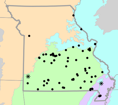
Natural Divisions Locality Map
Natural Divisions and Sections locality map for Necturus maculosus (Mudpuppy).
Map created 15 April 2026.
Major Watersheds Locality Map
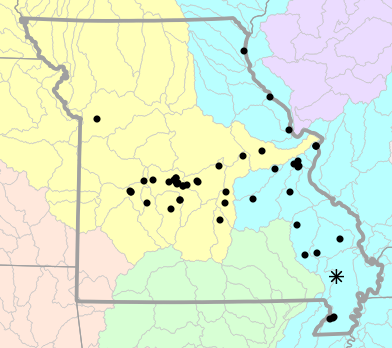
Major Watersheds locality map for Necturus maculosus (Mudpuppy).
Map created 15 April 2026.
Level I Ecoregion Locality Map

Level I Ecoregion locality map for Necturus maculosus (Mudpuppy).
Map created 15 April 2026.
Level II Ecoregion Locality Map
Level II Ecoregion locality map for Necturus maculosus (Mudpuppy).
Map created 15 April 2026.
Level III Ecoregion Locality Map
Level III Ecoregion locality map for Necturus maculosus (Mudpuppy).
Map created 15 April 2026.
Level IV Ecoregion Locality Map

Level IV Ecoregion locality map for Necturus maculosus (Mudpuppy).
Map created 15 April 2026.
Native Status
Necturus maculosus (Mudpuppy) is native to Missouri.
Collection Summary
Necturus maculosus (Mudpuppy) has a total of 67 valid, non-duplicated collections representing 27 counties and 50 localities. There are a total of 39 collectors and 48 collection dates for the species. This results in a total of 52 expeditions for the species, a measure of unique date / collector(s) combinations. The earliest collection year for the species in Missouri is 1885 and its most recent collection year is 2024. The earliest and latest collection dates (independent of earliest and most recent collection years) are January 25 and December 29, respectively. If you have a new record to report, read the New Records section of the FAQ.
Collection Summary by County
| County | Localities | Collections | Collectors | Dates | Expeditions | Earliest Year | Latest Year | |
|---|---|---|---|---|---|---|---|---|
 | Benton | 2 | 2 | 2 | 2 | 2 | 1941 | 1970 |
| Camden | 2 | 6 | 5 | 4 | 4 | 1951 | 1966 |
| Cape Girardeau | 1 | 1 | 1 | 1 | 1 | 1986 | 1986 |
| Crawford | 1 | 1 | 4 | 1 | 1 | 2006 | 2006 |
| Dallas | 1 | 1 | 6 | 1 | 1 | 2006 | 2006 |
| Dunklin | 3 | 4 | 3 | 2 | 3 | 1959 | 1966 |
| Franklin | 1 | 1 | 1 | 1 | 1 | 1942 | 1942 |
| Gasconade | 1 | 2 | 2 | 1 | 1 | 2006 | 2006 |
| Hickory | 1 | 1 | 1 | 1 | 1 | 1946 | 1946 |
| Iron | 1 | 1 | 1 | 1 | 1 | 1997 | 1997 |
| Jackson | 2 | 2 | 1 | 2 | 2 | 1937 | 1937 |
| Jefferson | 4 | 5 | 3 | 4 | 5 | 1899 | 2019 |
| Lewis | 1 | 1 | 1 | 1 | 1 | 2009 | 2009 |
| Lincoln | 1 | 1 | 3 | 1 | 1 | 2024 | 2024 |
| Maries | 1 | 1 | 4 | 1 | 1 | 2007 | 2007 |
| Miller | 3 | 4 | 3 | 3 | 3 | 1941 | 1979 |
| Morgan | 6 | 7 | 5 | 6 | 6 | 1905 | 1997 |
| Osage | 1 | 1 | 1 | 1 | 1 | 1983 | 1983 |
| Phelps | 1 | 1 | 1 | 1 | 1 | 1999 | 1999 |
| Pike | 2 | 2 | 2 | 2 | 2 | 1900 | 1900 |
| Pulaski | 1 | 1 | 2 | 1 | 1 | 2006 | 2006 |
| Saint Clair | 3 | 6 | 2 | 4 | 4 | 1938 | 1944 |
| Saint Louis | 2 | 6 | 2 | 4 | 5 | 1885 | 1906 |
| Stoddard | 1 | 2 | 2 | 2 | 2 | 1898 | 1898 |
| Warren | 1 | 1 | 1 | 1 | 1 | 2005 | 2005 |
| Washington | 1 | 1 | 1 | 1 | 1 | 1909 | 1909 |
| Wayne | 3 | 3 | 3 | 3 | 3 | 1910 | 1987 |
Potential County Records
| Likelihood | County | Rationale | Ecoregion / Watershed | |
|---|---|---|---|---|
 | 2 | Bollinger | Same watershed, within 5 miles | Whitewater |
| 2 | Clay | Same watershed, within 5 miles | Lower Missouri-Crooked |
| 2 | Cole | Same watershed, within 5 miles | Lower Osage |
| 2 | Laclede | Same watershed, within 5 miles | Niangua |
| 2 | Pemiscot | Same watershed, within 5 miles | Little River Ditches |
| 2 | Saint Charles | Same watershed, within 5 miles | The Sny |
| 2 | Saint Francois | Same watershed, within 5 miles | Big |
| 2 | Saint Francois | Same watershed, within 5 miles | Upper St. Francis |
| 2 | Texas | Same watershed, within 5 miles | Big Piney |
| 4 | Clark | Same watershed, within 10 miles | Bear-Wyaconda |
| 4 | Henry | Same watershed, within 10 miles | Harry S. Truman Reservoir |
| 4 | Madison | Same watershed, within 10 miles | Whitewater |
| 4 | Madison | Same watershed, within 10 miles | Upper St. Francis |
| 4 | Montgomery | Same watershed, within 10 miles | Lower Missouri |
| 4 | Polk | Same watershed, within 10 miles | Pomme De Terre |
| 4 | Ray | Same watershed, within 10 miles | Lower Missouri-Crooked |
| 4 | Reynolds | Same watershed, within 10 miles | Upper St. Francis |
 | 6 | Butler | Same watershed, within 20 miles | Lower St. Francis |
| 6 | Butler | Same watershed, within 20 miles | Upper St. Francis |
| 6 | Cedar | Same watershed, within 20 miles | Harry S. Truman Reservoir |
| 6 | Clinton | Same watershed, within 20 miles | Lower Missouri-Crooked |
| 6 | Dent | Same watershed, within 20 miles | Lower Gasconade |
| 6 | Dent | Same watershed, within 20 miles | Meramec |
| 6 | Lafayette | Same watershed, within 20 miles | Lower Missouri-Crooked |
| 6 | Marion | Same watershed, within 20 miles | Bear-Wyaconda |
| 6 | New Madrid | Same watershed, within 20 miles | Little River Ditches |
| 6 | Perry | Same watershed, within 20 miles | Whitewater |
| 6 | Platte | Same watershed, within 20 miles | Lower Missouri-Crooked |
| 6 | Ralls | Same watershed, within 20 miles | The Sny |
| 6 | Sainte Genevieve | Same watershed, within 20 miles | Big |
| 6 | Scott | Same watershed, within 20 miles | Whitewater |
 | 8 | Bates | Same watershed, within 30 miles | Harry S. Truman Reservoir |
| 8 | Caldwell | Same watershed, within 30 miles | Lower Missouri-Crooked |
| 8 | Callaway | Same watershed, within 30 miles | Lower Missouri |
| 8 | Carroll | Same watershed, within 30 miles | Lower Missouri-Crooked |
| 8 | Cass | Same watershed, within 30 miles | Lower Missouri-Crooked |
| 8 | Johnson | Same watershed, within 30 miles | Lower Missouri-Crooked |
| 8 | Scotland | Same watershed, within 30 miles | Bear-Wyaconda |
| 8 | Vernon | Same watershed, within 30 miles | Harry S. Truman Reservoir |
| 8 | Webster | Same watershed, within 30 miles | Niangua |
| 10 | Audrain | Adjacent county, same watershed | Lower Missouri |
| 10 | Greene | Adjacent county, same watershed | Pomme De Terre |
| 10 | Knox | Adjacent county, same watershed | The Sny |
| 10 | Shelby | Adjacent county, same watershed | The Sny |
Linnaean Classification
- Kingdom:
- Animalia - Animals
- Phylum:
- Chordata - Chordates
- Subphylum:
- Vertebrata - Vertebrates
- Class:
- Amphibia Gray, 1825 - Amphibians
- Order:
- Caudata Scopoli, 1777 - Salamanders
- Family:
- Proteidae Gray, 1825 - Mudpuppies and Olms
- Genus:
- Necturus Rafinesque, 1819 - Waterdogs and Mudpuppies
- Species:
- Necturus maculosus (Rafinesque, 1818) - Mudpuppy
Recent Taxonomic Synonyms
(none)