Maps
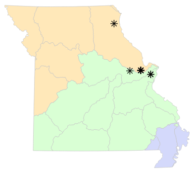
Locality Map

Locality map for Sistrurus catenatus (Eastern Massasauga).
Map created 6 March 2024.
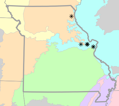
County Map

County map for Sistrurus catenatus (Eastern Massasauga).
Map created 6 March 2024.
Historical Locality Map

Historical locality map for Sistrurus catenatus (Eastern Massasauga). Black circles (  ) represent records after 1986, blue squares (
  ) represent records between 1966 and 1986, orange triangles (
  ) represent records prior to 1966. Note that more recent records might conceal underlying older records.
Map created 6 March 2024.
Historical County Map

Historical county map for Sistrurus catenatus (Eastern Massasauga). Black circles ( ) represent records after 1986, blue squares ( ) represent records between 1966 and 1986, orange triangles ( ) represent records prior to 1966. Note that only the most recent county record for each county is shown.
Map created 6 March 2024.
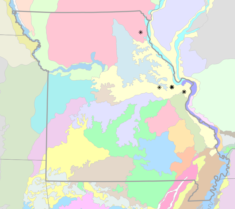
Ecological Drainage Locality Map
Ecological Drainage Units locality map for Sistrurus catenatus (Eastern Massasauga).
Map created 6 March 2024.
Natural Divisions Locality Map

Natural Divisions and Sections locality map for Sistrurus catenatus (Eastern Massasauga).
Map created 6 March 2024.
Major Watersheds Locality Map

Major Watersheds locality map for Sistrurus catenatus (Eastern Massasauga).
Map created 6 March 2024.
Level I Ecoregion Locality Map

Level I Ecoregion locality map for Sistrurus catenatus (Eastern Massasauga).
Map created 6 March 2024.
Level II Ecoregion Locality Map

Level II Ecoregion locality map for Sistrurus catenatus (Eastern Massasauga).
Map created 6 March 2024.
Level III Ecoregion Locality Map
Level III Ecoregion locality map for Sistrurus catenatus (Eastern Massasauga).
Map created 6 March 2024.
Level IV Ecoregion Locality Map
Level IV Ecoregion locality map for Sistrurus catenatus (Eastern Massasauga).
Map created 6 March 2024.
Native Status
Sistrurus catenatus (Eastern Massasauga) is native to Missouri.
Collection Summary
Sistrurus catenatus (Eastern Massasauga) has a total of 40 valid, non-duplicated collections representing 4 counties and 13 localities. There are a total of 7 collectors and 9 collection dates for the species. This results in a total of 10 expeditions for the species, a measure of unique date / collector(s) combinations. The earliest collection year for the species in Missouri is 1899 and its most recent collection year is 1941. The earliest and latest collection dates (independent of earliest and most recent collection years) are March 20 and September 28, respectively. If you have a new record to report, read the New Records section of the FAQ.
Collection Summary by County
| County | Localities | Collections | Collectors | Dates | Expeditions | Earliest Year | Latest Year | |
|---|---|---|---|---|---|---|---|---|
 | Lewis | 1 | 2 | 1 | 1 | 1 | ||
| Saint Charles | 8 | 32 | 6 | 9 | 9 | 1899 | 1941 |
| Saint Louis | 3 | 4 | 2 | 1 | 2 | ||
| Warren | 1 | 2 | 1 | 1 | 1 |
Potential County Records
| Likelihood | County | Rationale | Ecoregion / Watershed | |
|---|---|---|---|---|
 | 2 | Franklin | Same Level IV ecoregion, within 5 miles | River Hills |
| 2 | Jefferson | Same Level IV ecoregion, within 5 miles | Eastern Ozark Border |
| 2 | Lincoln | Same Level IV ecoregion, within 5 miles | Upper Mississippi Alluvial Plain |
 | 6 | Gasconade | Same Level IV ecoregion, within 20 miles | River Hills |
| 6 | Montgomery | Same Level IV ecoregion, within 20 miles | River Hills |
 | 8 | Pike | Same Level IV ecoregion, within 30 miles | Upper Mississippi Alluvial Plain |
| 9 | Washington | Same Level III ecoregion, within 30 miles | Ozark Highlands |
| 10 | Clark | Same Level IV ecoregion, adjacent county | Upper Mississippi Alluvial Plain |
| 10 | Marion | Same Level IV ecoregion, adjacent county | Upper Mississippi Alluvial Plain |
| 10 | Marion | Same Level IV ecoregion, adjacent county | River Hills |
| 10 | Shelby | Same Level IV ecoregion, adjacent county | River Hills |
Linnaean Classification
- Kingdom:
- Animalia - Animals
- Phylum:
- Chordata - Chordates
- Subphylum:
- Vertebrata - Vertebrates
- Class:
- Reptilia Laurenti, 1768 - Reptiles
- Order:
- Squamata Oppel, 1811 - Lizards and Snakes
- Suborder:
- Serpentes Linnaeus, 1758 - Snakes
- Family:
- Viperidae Bonaparte, 1840 - Asps and Vipers
- Genus:
- Sistrurus Garman, 1883 - Massasaugas and Pygmy Rattlesnakes
- Species:
- Sistrurus catenatus (Rafinesque, 1818) - Eastern Massasauga
Recent Taxonomic Synonyms
(none)