Maps
Locality Map

Locality map for Lampropeltis nigra (Eastern Black Kingsnake).
Map created 6 March 2024.
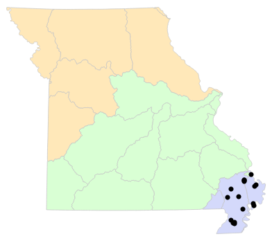
County Map

County map for Lampropeltis nigra (Eastern Black Kingsnake).
Map created 6 March 2024.
Historical Locality Map

Historical locality map for Lampropeltis nigra (Eastern Black Kingsnake). Black circles (  ) represent records after 1986, blue squares (
  ) represent records between 1966 and 1986, orange triangles (
  ) represent records prior to 1966. Note that more recent records might conceal underlying older records.
Map created 6 March 2024.
Historical County Map

Historical county map for Lampropeltis nigra (Eastern Black Kingsnake). Black circles ( ) represent records after 1986, blue squares ( ) represent records between 1966 and 1986, orange triangles ( ) represent records prior to 1966. Note that only the most recent county record for each county is shown.
Map created 6 March 2024.
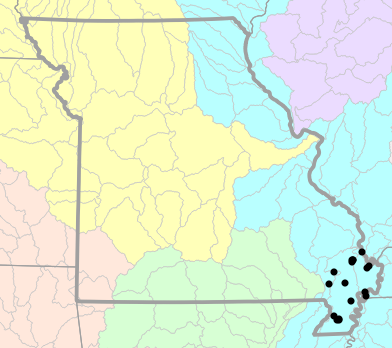
Ecological Drainage Locality Map
Ecological Drainage Units locality map for Lampropeltis nigra (Eastern Black Kingsnake).
Map created 6 March 2024.
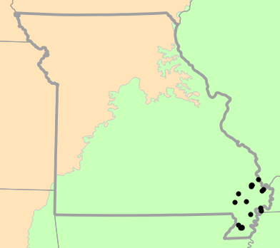
Natural Divisions Locality Map

Natural Divisions and Sections locality map for Lampropeltis nigra (Eastern Black Kingsnake).
Map created 6 March 2024.
Major Watersheds Locality Map
Major Watersheds locality map for Lampropeltis nigra (Eastern Black Kingsnake).
Map created 6 March 2024.
Level I Ecoregion Locality Map
Level I Ecoregion locality map for Lampropeltis nigra (Eastern Black Kingsnake).
Map created 6 March 2024.
Level II Ecoregion Locality Map

Level II Ecoregion locality map for Lampropeltis nigra (Eastern Black Kingsnake).
Map created 6 March 2024.
Level III Ecoregion Locality Map

Level III Ecoregion locality map for Lampropeltis nigra (Eastern Black Kingsnake).
Map created 6 March 2024.
Level IV Ecoregion Locality Map

Level IV Ecoregion locality map for Lampropeltis nigra (Eastern Black Kingsnake).
Map created 6 March 2024.
Native Status
Lampropeltis nigra (Eastern Black Kingsnake) is native to Missouri.
Collection Summary
Lampropeltis nigra (Eastern Black Kingsnake) has a total of 19 valid, non-duplicated collections representing 6 counties and 19 localities. There are a total of 15 collectors and 15 collection dates for the species. This results in a total of 16 expeditions for the species, a measure of unique date / collector(s) combinations. The earliest collection year for the species in Missouri is 1932 and its most recent collection year is 2022. The earliest and latest collection dates (independent of earliest and most recent collection years) are March 22 and October 19, respectively. If you have a new record to report, read the New Records section of the FAQ.
Collection Summary by County
| County | Localities | Collections | Collectors | Dates | Expeditions | Earliest Year | Latest Year | |
|---|---|---|---|---|---|---|---|---|
 | Dunklin | 2 | 2 | 2 | 2 | 2 | 1932 | 1936 |
| Mississippi | 2 | 2 | 3 | 2 | 2 | 1987 | 2011 |
| New Madrid | 3 | 3 | 4 | 3 | 3 | 1986 | 2021 |
| Pemiscot | 3 | 3 | 3 | 2 | 3 | 1934 | 1957 |
| Scott | 6 | 6 | 4 | 4 | 4 | 1995 | 2021 |
| Stoddard | 3 | 3 | 4 | 3 | 3 | 1938 | 2022 |
Potential County Records
| Likelihood | County | Rationale | Ecoregion / Watershed | |
|---|---|---|---|---|
 | 2 | Butler | Same Level IV ecoregion, within 5 miles | Western Lowlands Pleistocene Valley Trains |
| 4 | Cape Girardeau | Same Level IV ecoregion, within 10 miles | St. Francis Lowlands |
| 4 | Cape Girardeau | Same Level IV ecoregion, within 10 miles | River Hills |
 | 6 | Bollinger | Same Level IV ecoregion, within 20 miles | St. Francis Lowlands |
| 6 | Bollinger | Same Level IV ecoregion, within 20 miles | Bluff Hills |
| 6 | Wayne | Same Level IV ecoregion, within 20 miles | Western Lowlands Pleistocene Valley Trains |
 | 8 | Ripley | Same Level IV ecoregion, within 30 miles | Western Lowlands Pleistocene Valley Trains |
Linnaean Classification
- Kingdom:
- Animalia - Animals
- Phylum:
- Chordata - Chordates
- Subphylum:
- Vertebrata - Vertebrates
- Class:
- Reptilia Laurenti, 1768 - Reptiles
- Order:
- Squamata Oppel, 1811 - Lizards and Snakes
- Suborder:
- Serpentes Linnaeus, 1758 - Snakes
- Family:
- Colubridae Oppel, 1811 - Typical Harmless Snakes
- Genus:
- Lampropeltis Fitzinger, 1843 - Kingsnakes and Milksnakes
- Species:
- Lampropeltis nigra (Yarrow, 1882) - Eastern Black Kingsnake
Recent Taxonomic Synonyms
(none)