Maps
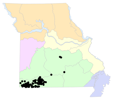
Locality Map

Locality map for Eurycea tynerensis (Oklahoma Salamander).
Map created 15 April 2026.
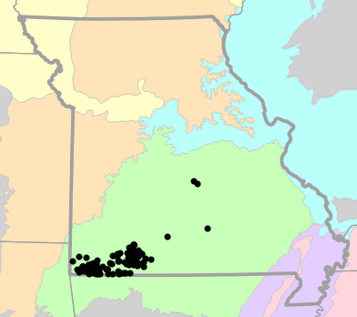
County Map

County map for Eurycea tynerensis (Oklahoma Salamander).
Map created 15 April 2026.
Historical Locality Map

Historical locality map for Eurycea tynerensis (Oklahoma Salamander). Black circles (  ) represent records after 1986, blue squares (
  ) represent records between 1966 and 1986, orange triangles (
  ) represent records prior to 1966. Note that more recent records might conceal underlying older records.
Map created 15 April 2026.
Historical County Map

Historical county map for Eurycea tynerensis (Oklahoma Salamander). Black circles ( ) represent records after 1986, blue squares ( ) represent records between 1966 and 1986, orange triangles ( ) represent records prior to 1966. Note that only the most recent county record for each county is shown.
Map created 15 April 2026.
Ecological Drainage Locality Map

Ecological Drainage Units locality map for Eurycea tynerensis (Oklahoma Salamander).
Map created 15 April 2026.
Natural Divisions Locality Map
Natural Divisions and Sections locality map for Eurycea tynerensis (Oklahoma Salamander).
Map created 15 April 2026.
Major Watersheds Locality Map

Major Watersheds locality map for Eurycea tynerensis (Oklahoma Salamander).
Map created 15 April 2026.
Level I Ecoregion Locality Map

Level I Ecoregion locality map for Eurycea tynerensis (Oklahoma Salamander).
Map created 15 April 2026.
Level II Ecoregion Locality Map

Level II Ecoregion locality map for Eurycea tynerensis (Oklahoma Salamander).
Map created 15 April 2026.
Level III Ecoregion Locality Map
Level III Ecoregion locality map for Eurycea tynerensis (Oklahoma Salamander).
Map created 15 April 2026.
Level IV Ecoregion Locality Map

Level IV Ecoregion locality map for Eurycea tynerensis (Oklahoma Salamander).
Map created 15 April 2026.
Native Status
Eurycea tynerensis (Oklahoma Salamander) is native to Missouri.
Collection Summary
Eurycea tynerensis (Oklahoma Salamander) has a total of 472 valid, non-duplicated collections representing 9 counties and 106 localities. There are a total of 40 collectors and 91 collection dates for the species. This results in a total of 101 expeditions for the species, a measure of unique date / collector(s) combinations. The earliest collection year for the species in Missouri is 1910 and its most recent collection year is 2023. The earliest and latest collection dates (independent of earliest and most recent collection years) are January 3 and December 28, respectively. If you have a new record to report, read the New Records section of the FAQ.
Collection Summary by County
| County | Localities | Collections | Collectors | Dates | Expeditions | Earliest Year | Latest Year | |
|---|---|---|---|---|---|---|---|---|
 | Barry | 22 | 77 | 14 | 22 | 23 | 1930 | 1986 |
| Christian | 5 | 8 | 8 | 7 | 7 | 1984 | 2023 |
| McDonald | 28 | 182 | 5 | 25 | 25 | 1952 | 1985 |
| Newton | 2 | 2 | 2 | 1 | 2 | 1985 | 1985 |
| Pulaski | 2 | 4 | 1 | 2 | 2 | 1950 | 1967 |
| Stone | 31 | 159 | 22 | 35 | 40 | 1910 | 2012 |
| Taney | 12 | 29 | 7 | 8 | 10 | 1950 | 2014 |
| Texas | 1 | 1 | 1 | 1 | 1 | 1940 | 1940 |
| Wright | 1 | 1 | 1 | 1 | 1 | 2020 | 2020 |
Potential County Records
| Likelihood | County | Rationale | Ecoregion / Watershed | |
|---|---|---|---|---|
 | 2 | Maries | Same Level IV ecoregion, within 5 miles | Osage/Gasconade Hills |
| 2 | Miller | Same Level IV ecoregion, within 5 miles | Osage/Gasconade Hills |
| 2 | Phelps | Same Level IV ecoregion, within 5 miles | Osage/Gasconade Hills |
| 2 | Webster | Same Level IV ecoregion, within 5 miles | Central Plateau |
| 3 | Douglas | Same Level III ecoregion, within 5 miles | Ozark Highlands |
| 4 | Greene | Same Level IV ecoregion, within 10 miles | Springfield Plateau |
| 4 | Howell | Same Level IV ecoregion, within 10 miles | Central Plateau |
| 5 | Lawrence | Same Level III ecoregion, within 10 miles | Ozark Highlands |
 | 6 | Camden | Same Level IV ecoregion, within 20 miles | Osage/Gasconade Hills |
| 6 | Dent | Same Level IV ecoregion, within 20 miles | Osage/Gasconade Hills |
| 6 | Dent | Same Level IV ecoregion, within 20 miles | Central Plateau |
| 6 | Jasper | Same Level IV ecoregion, within 20 miles | Springfield Plateau |
| 6 | Laclede | Same Level IV ecoregion, within 20 miles | Osage/Gasconade Hills |
| 6 | Ozark | Same Level IV ecoregion, within 20 miles | White River Hills |
| 6 | Shannon | Same Level IV ecoregion, within 20 miles | Central Plateau |
 | 8 | Cole | Same Level IV ecoregion, within 30 miles | Osage/Gasconade Hills |
| 8 | Dade | Same Level IV ecoregion, within 30 miles | Springfield Plateau |
| 8 | Dallas | Same Level IV ecoregion, within 30 miles | Central Plateau |
| 8 | Gasconade | Same Level IV ecoregion, within 30 miles | Osage/Gasconade Hills |
| 8 | Oregon | Same Level IV ecoregion, within 30 miles | Central Plateau |
| 8 | Osage | Same Level IV ecoregion, within 30 miles | Osage/Gasconade Hills |
| 9 | Crawford | Same Level III ecoregion, within 30 miles | Ozark Highlands |
Linnaean Classification
- Kingdom:
- Animalia - Animals
- Phylum:
- Chordata - Chordates
- Subphylum:
- Vertebrata - Vertebrates
- Class:
- Amphibia Gray, 1825 - Amphibians
- Order:
- Caudata Scopoli, 1777 - Salamanders
- Family:
- Plethodontidae Gray, 1850 - Lungless Salamanders
- Genus:
- Eurycea Rafinesque, 1822 - Brook Salamanders
- Species:
- Eurycea tynerensis Moore and Hughes, 1939 - Oklahoma Salamander
Recent Taxonomic Synonyms
- Eurycea multiplicata