Maps
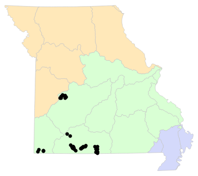
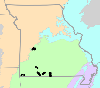
Locality Map
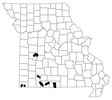
Locality map for Sonora episcopa (Great Plains Groundsnake).
Map created 15 April 2026.
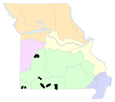
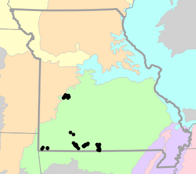
County Map
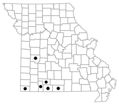
County map for Sonora episcopa (Great Plains Groundsnake).
Map created 15 April 2026.
Historical Locality Map
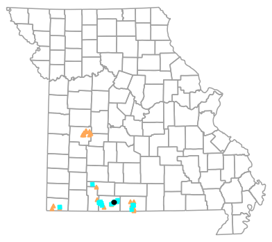
Historical locality map for Sonora episcopa (Great Plains Groundsnake). Black circles (  ) represent records after 1986, blue squares (
  ) represent records between 1966 and 1986, orange triangles (
  ) represent records prior to 1966. Note that more recent records might conceal underlying older records.
Map created 15 April 2026.
Historical County Map
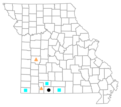
Historical county map for Sonora episcopa (Great Plains Groundsnake). Black circles ( ) represent records after 1986, blue squares ( ) represent records between 1966 and 1986, orange triangles ( ) represent records prior to 1966. Note that only the most recent county record for each county is shown.
Map created 15 April 2026.
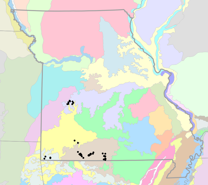
Ecological Drainage Locality Map
Ecological Drainage Units locality map for Sonora episcopa (Great Plains Groundsnake).
Map created 15 April 2026.
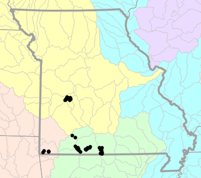
Natural Divisions Locality Map
Natural Divisions and Sections locality map for Sonora episcopa (Great Plains Groundsnake).
Map created 15 April 2026.
Major Watersheds Locality Map
Major Watersheds locality map for Sonora episcopa (Great Plains Groundsnake).
Map created 15 April 2026.
Level I Ecoregion Locality Map
Level I Ecoregion locality map for Sonora episcopa (Great Plains Groundsnake).
Map created 15 April 2026.
Level II Ecoregion Locality Map
Level II Ecoregion locality map for Sonora episcopa (Great Plains Groundsnake).
Map created 15 April 2026.
Level III Ecoregion Locality Map
Level III Ecoregion locality map for Sonora episcopa (Great Plains Groundsnake).
Map created 15 April 2026.
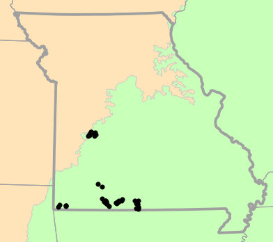
Level IV Ecoregion Locality Map
Level IV Ecoregion locality map for Sonora episcopa (Great Plains Groundsnake).
Map created 15 April 2026.
Native Status
Sonora episcopa (Great Plains Groundsnake) is native to Missouri.
Collection Summary
Sonora episcopa (Great Plains Groundsnake) has a total of 284 valid, non-duplicated collections representing 6 counties and 44 localities. There are a total of 29 collectors and 67 collection dates for the species. This results in a total of 77 expeditions for the species, a measure of unique date / collector(s) combinations. The earliest collection year for the species in Missouri is 1937 and its most recent collection year is 2012. The earliest and latest collection dates (independent of earliest and most recent collection years) are March 1 and September 27, respectively. If you have a new record to report, read the New Records section of the FAQ.
Collection Summary by County
| County | Localities | Collections | Collectors | Dates | Expeditions | Earliest Year | Latest Year | |
|---|---|---|---|---|---|---|---|---|
 | Christian | 1 | 1 | 1 | 1 | 1 | 1967 | 1967 |
| McDonald | 4 | 29 | 6 | 9 | 9 | 1958 | 1982 |
| Ozark | 10 | 68 | 5 | 12 | 14 | 1961 | 1982 |
| Saint Clair | 9 | 77 | 6 | 17 | 21 | 1937 | 1942 |
| Stone | 2 | 2 | 2 | 2 | 2 | 1946 | 1946 |
| Taney | 18 | 107 | 21 | 30 | 34 | 1946 | 2012 |
Potential County Records
| Likelihood | County | Rationale | Ecoregion / Watershed | |
|---|---|---|---|---|
 | 2 | Benton | Same Level IV ecoregion, within 5 miles | Osage/Gasconade Hills |
| 2 | Greene | Same Level IV ecoregion, within 5 miles | Springfield Plateau |
| 2 | Henry | Same Level IV ecoregion, within 5 miles | Osage/Gasconade Hills |
| 2 | Hickory | Same Level IV ecoregion, within 5 miles | Osage/Gasconade Hills |
| 4 | Douglas | Same Level IV ecoregion, within 10 miles | White River Hills |
| 4 | Lawrence | Same Level IV ecoregion, within 10 miles | Springfield Plateau |
 | 6 | Barry | Same Level IV ecoregion, within 20 miles | Springfield Plateau |
| 6 | Barry | Same Level IV ecoregion, within 20 miles | White River Hills |
| 6 | Barry | Same Level IV ecoregion, within 20 miles | Dissected Springfield Plateau-Elk River Hills |
| 6 | Cedar | Same Level IV ecoregion, within 20 miles | Osage/Gasconade Hills |
| 6 | Dade | Same Level IV ecoregion, within 20 miles | Springfield Plateau |
| 6 | Howell | Same Level IV ecoregion, within 20 miles | White River Hills |
| 6 | Newton | Same Level IV ecoregion, within 20 miles | Dissected Springfield Plateau-Elk River Hills |
| 6 | Polk | Same Level IV ecoregion, within 20 miles | Osage/Gasconade Hills |
 | 8 | Camden | Same Level IV ecoregion, within 30 miles | Osage/Gasconade Hills |
| 8 | Dallas | Same Level IV ecoregion, within 30 miles | Osage/Gasconade Hills |
| 8 | Morgan | Same Level IV ecoregion, within 30 miles | Osage/Gasconade Hills |
| 8 | Texas | Same Level IV ecoregion, within 30 miles | White River Hills |
| 8 | Webster | Same Level IV ecoregion, within 30 miles | White River Hills |
| 8 | Webster | Same Level IV ecoregion, within 30 miles | Springfield Plateau |
| 8 | Wright | Same Level IV ecoregion, within 30 miles | White River Hills |
| 9 | Pettis | Same Level III ecoregion, within 30 miles | Ozark Highlands |
Linnaean Classification
- Kingdom:
- Animalia - Animals
- Phylum:
- Chordata - Chordates
- Subphylum:
- Vertebrata - Vertebrates
- Class:
- Reptilia Laurenti, 1768 - Reptiles
- Order:
- Squamata Oppel, 1811 - Lizards and Snakes
- Family:
- Colubridae Oppel, 1811 - Harmless Egg-laying Snakes
- Genus:
- Sonora Baird and Girard, 1853 - North American Groundsnakes
- Species:
- Sonora episcopa (Kennicott in Baird, 1859) - Great Plains Groundsnake
Recent Taxonomic Synonyms
- Sonora semiannulata