Maps
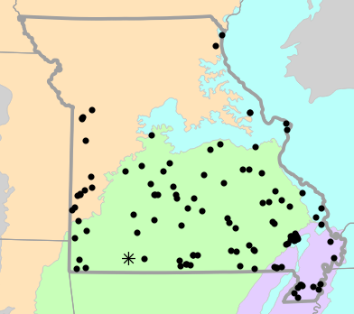
Locality Map

Locality map for Sternotherus odoratus (Eastern Musk Turtle).
Map created 3 August 2022.
County Map

County map for Sternotherus odoratus (Eastern Musk Turtle).
Map created 3 August 2022.
Historical Locality Map

Historical locality map for Sternotherus odoratus (Eastern Musk Turtle). Black circles (  ) represent records after 1986, blue squares (
  ) represent records between 1966 and 1986, orange triangles (
  ) represent records prior to 1966. Note that more recent records might conceal underlying older records.
Map created 3 August 2022.
Historical County Map

Historical county map for Sternotherus odoratus (Eastern Musk Turtle). Black circles ( ) represent records after 1986, blue squares ( ) represent records between 1966 and 1986, orange triangles ( ) represent records prior to 1966. Note that only the most recent county record for each county is shown.
Map created 3 August 2022.
Ecological Drainage Locality Map

Ecological Drainage Units locality map for Sternotherus odoratus (Eastern Musk Turtle).
Map created 3 August 2022.
Natural Divisions Locality Map

Natural Divisions and Sections locality map for Sternotherus odoratus (Eastern Musk Turtle).
Map created 3 August 2022.
Major Watersheds Locality Map

Major Watersheds locality map for Sternotherus odoratus (Eastern Musk Turtle).
Map created 3 August 2022.
Level I Ecoregion Locality Map

Level I Ecoregion locality map for Sternotherus odoratus (Eastern Musk Turtle).
Map created 3 August 2022.
Level II Ecoregion Locality Map
Level II Ecoregion locality map for Sternotherus odoratus (Eastern Musk Turtle).
Map created 3 August 2022.
Level III Ecoregion Locality Map

Level III Ecoregion locality map for Sternotherus odoratus (Eastern Musk Turtle).
Map created 3 August 2022.
Level IV Ecoregion Locality Map

Level IV Ecoregion locality map for Sternotherus odoratus (Eastern Musk Turtle).
Map created 3 August 2022.
Native Status
Sternotherus odoratus (Eastern Musk Turtle) is native to Missouri.
Collection Summary
Sternotherus odoratus (Eastern Musk Turtle) has a total of 149 valid, non-duplicated collections representing 53 counties and 117 localities. There are a total of 80 collectors and 98 collection dates for the species. This results in a total of 105 expeditions for the species, a measure of unique date / collector(s) combinations. The earliest collection year for the species in Missouri is 1892 and its most recent collection year is 2021. The earliest and latest collection dates (independent of earliest and most recent collection years) are February 6 and November 4, respectively. If you have a new record to report, read the New Records section of the FAQ.
Collection Summary by County
| County | Localities | Collections | Collectors | Dates | Expeditions | Earliest Year | Latest Year | |
|---|---|---|---|---|---|---|---|---|
 | Barton | 1 | 1 | 1 | 1 | 1 | 2010 | 2010 |
| Bates | 1 | 1 | 1 | 1 | 1 | 1989 | 1989 |
| Benton | 1 | 1 | 1 | 1 | 1 | 1968 | 1968 |
| Bollinger | 3 | 3 | 3 | 3 | 3 | 1966 | 2009 |
| Butler | 5 | 5 | 4 | 5 | 5 | 1949 | 1996 |
| Camden | 2 | 5 | 2 | 2 | 2 | 1967 | 1978 |
| Cape Girardeau | 3 | 4 | 3 | 3 | 3 | 1904 | 2007 |
| Carter | 5 | 6 | 12 | 4 | 5 | 1930 | 2004 |
| Cass | 1 | 1 | 1 | 1 | 1 | 1987 | 1987 |
| Clark | 1 | 1 | 1 | 1 | 1 | 2013 | 2013 |
| Cooper | 1 | 1 | 1 | 1 | 1 | 2006 | 2006 |
| Crawford | 2 | 2 | 3 | 2 | 2 | 1983 | 2014 |
| Dallas | 2 | 2 | 3 | 2 | 2 | 1987 | 2016 |
| Dunklin | 7 | 11 | 5 | 6 | 6 | 1909 | 1966 |
| Franklin | 1 | 1 | 1 | 1 | 1 | 2015 | 2015 |
| Gasconade | 1 | 1 | 2 | 1 | 1 | 2006 | 2006 |
| Greene | 1 | 1 | 1 | 1 | 1 | 1999 | 1999 |
| Howell | 1 | 1 | 1 | 1 | 1 | 1969 | 1969 |
| Iron | 2 | 2 | 3 | 1 | 1 | ||
| Jackson | 4 | 4 | 1 | 2 | 2 | 1938 | 1938 |
| Jasper | 3 | 3 | 2 | 2 | 2 | 2020 | 2020 |
| Laclede | 3 | 3 | 3 | 2 | 3 | 2010 | 2012 |
| Lewis | 1 | 1 | 1 | 1 | 1 | 1961 | 1961 |
| Lincoln | 2 | 2 | 1 | 2 | 2 | 1997 | 2014 |
| Madison | 2 | 2 | 2 | 2 | 2 | 2003 | 2003 |
| Maries | 1 | 1 | 1 | 1 | 1 | 1982 | 1982 |
| McDonald | 3 | 6 | 2 | 3 | 3 | 1975 | 1984 |
| Miller | 1 | 1 | 1 | 1 | 1 | 1993 | 1993 |
| Mississippi | 2 | 2 | 3 | 2 | 2 | 1984 | 2007 |
| Newton | 1 | 1 | 1 | 1 | 1 | 1976 | 1976 |
| Oregon | 3 | 3 | 3 | 3 | 3 | 1941 | 2005 |
| Osage | 1 | 1 | 2 | 1 | 1 | 2006 | 2006 |
| Ozark | 6 | 11 | 5 | 6 | 7 | 1892 | 1969 |
| Pemiscot | 4 | 5 | 3 | 3 | 3 | 1920 | 1938 |
| Perry | 1 | 1 | 1 | 1 | 1 | 2017 | 2017 |
| Polk | 1 | 1 | 2 | 1 | 1 | 1940 | 1940 |
| Pulaski | 1 | 1 | 2 | 1 | 1 | 2004 | 2004 |
| Ripley | 1 | 1 | 1 | 1 | 1 | 1986 | 1986 |
| Saint Charles | 1 | 1 | 1 | 1 | 1 | 1992 | 1992 |
| Saint Clair | 1 | 1 | 1 | 1 | 1 | 2015 | 2015 |
| Saint Francois | 1 | 1 | 1 | 1 | 1 | 2007 | 2007 |
| Saint Louis | 1 | 1 | 1 | 1 | 1 | ||
| Scott | 1 | 1 | 2 | 1 | 1 | 1995 | 1995 |
| Shannon | 3 | 3 | 7 | 3 | 3 | 2003 | 2010 |
| Stoddard | 5 | 13 | 7 | 9 | 9 | 1965 | 2021 |
| Stone | 1 | 1 | 1 | 1 | 1 | 1949 | 1949 |
| Taney | 1 | 2 | 1 | 1 | 1 | ||
| Texas | 2 | 2 | 2 | 2 | 2 | 2004 | 2007 |
| Vernon | 5 | 7 | 4 | 5 | 5 | 1904 | 2006 |
| Washington | 3 | 4 | 2 | 4 | 4 | 1909 | 1983 |
| Wayne | 6 | 7 | 7 | 6 | 6 | 1939 | 2020 |
| Webster | 1 | 1 | 1 | 1 | 1 | 1966 | 1966 |
| Wright | 1 | 1 | 3 | 1 | 1 | 1940 | 1940 |
Potential County Records
| Likelihood | County | Rationale | Ecoregion / Watershed | |
|---|---|---|---|---|
 | 2 | Christian | Same watershed, within 5 miles | James |
| 2 | Douglas | Same watershed, within 5 miles | North Fork White |
| 2 | Hickory | Same watershed, within 5 miles | Harry S. Truman Reservoir |
| 2 | Jefferson | Same watershed, within 5 miles | Meramec |
| 2 | Jefferson | Same watershed, within 5 miles | Big |
| 2 | Morgan | Same watershed, within 5 miles | Lake of the Ozarks |
| 2 | Morgan | Same watershed, within 5 miles | Lamine |
| 2 | New Madrid | Same watershed, within 5 miles | Town of Madrid-Saint Johns Bayou |
| 2 | New Madrid | Same watershed, within 5 miles | Lower Mississippi-Memphis |
| 2 | Pettis | Same watershed, within 5 miles | Lamine |
| 2 | Phelps | Same watershed, within 5 miles | Big Piney |
| 2 | Phelps | Same watershed, within 5 miles | Lower Gasconade |
| 2 | Phelps | Same watershed, within 5 miles | Meramec |
| 2 | Reynolds | Same watershed, within 5 miles | Upper St. Francis |
| 4 | Cedar | Same watershed, within 10 miles | Harry S. Truman Reservoir |
| 4 | Clay | Same watershed, within 10 miles | Lower Missouri-Crooked |
| 4 | Dent | Same watershed, within 10 miles | Current |
| 4 | Henry | Same watershed, within 10 miles | Harry S. Truman Reservoir |
| 4 | Lafayette | Same watershed, within 10 miles | Lower Missouri-Crooked |
| 4 | Moniteau | Same watershed, within 10 miles | Lamine |
| 4 | Ray | Same watershed, within 10 miles | Lower Missouri-Crooked |
| 4 | Sainte Genevieve | Same watershed, within 10 miles | Whitewater |
| 4 | Sainte Genevieve | Same watershed, within 10 miles | Big |
| 4 | Sainte Genevieve | Same watershed, within 10 miles | Upper Mississippi-Cape Girardeau |
| 4 | Sainte Genevieve | Same watershed, within 10 miles | Upper St. Francis |
 | 6 | Barry | Same watershed, within 20 miles | Elk |
| 6 | Cole | Same watershed, within 20 miles | Lower Osage |
| 6 | Dade | Same watershed, within 20 miles | Spring |
| 6 | Dade | Same watershed, within 20 miles | Sac |
| 6 | Johnson | Same watershed, within 20 miles | South Grand |
| 6 | Johnson | Same watershed, within 20 miles | Lower Missouri-Crooked |
| 6 | Lawrence | Same watershed, within 20 miles | Sac |
| 6 | Lawrence | Same watershed, within 20 miles | Spring |
| 6 | Marion | Same watershed, within 20 miles | Bear-Wyaconda |
| 6 | Montgomery | Same watershed, within 20 miles | Cuivre |
| 6 | Pike | Same watershed, within 20 miles | Cuivre |
| 6 | Platte | Same watershed, within 20 miles | Lower Missouri-Crooked |
| 6 | Saline | Same watershed, within 20 miles | Lamine |
| 6 | Warren | Same watershed, within 20 miles | Cuivre |
 | 8 | Audrain | Same watershed, within 30 miles | Cuivre |
| 8 | Caldwell | Same watershed, within 30 miles | Lower Missouri-Crooked |
| 8 | Carroll | Same watershed, within 30 miles | Lower Missouri-Crooked |
| 8 | Clinton | Same watershed, within 30 miles | Lower Missouri-Crooked |
| 8 | Scotland | Same watershed, within 30 miles | Bear-Wyaconda |
Linnaean Classification
- Kingdom:
- Animalia - Animals
- Phylum:
- Chordata - Chordates
- Subphylum:
- Vertebrata - Vertebrates
- Class:
- Reptilia Laurenti, 1768 - Reptiles
- Order:
- Testudines Linnaeus, 1758 - Turtles
- Family:
- Kinosternidae Agassiz, 1857 - Mud and Musk Turtles
- Genus:
- Sternotherus Gray, 1825 - Musk Turtles
- Species:
- Sternotherus odoratus (Latreille in Sonnini and Latreille, 1801) - Eastern Musk Turtle
Recent Taxonomic Synonyms
(none)