Maps
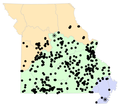
Locality Map

Locality map for Sceloporus consobrinus (Prairie Lizard).
Map created 15 April 2026.
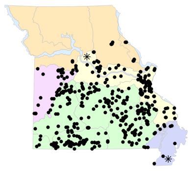
County Map

County map for Sceloporus consobrinus (Prairie Lizard).
Map created 15 April 2026.
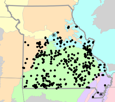
Historical Locality Map
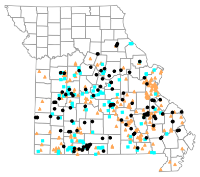
Historical locality map for Sceloporus consobrinus (Prairie Lizard). Black circles (  ) represent records after 1986, blue squares (
  ) represent records between 1966 and 1986, orange triangles (
  ) represent records prior to 1966. Note that more recent records might conceal underlying older records.
Map created 15 April 2026.
Historical County Map

Historical county map for Sceloporus consobrinus (Prairie Lizard). Black circles ( ) represent records after 1986, blue squares ( ) represent records between 1966 and 1986, orange triangles ( ) represent records prior to 1966. Note that only the most recent county record for each county is shown.
Map created 15 April 2026.
Ecological Drainage Locality Map
Ecological Drainage Units locality map for Sceloporus consobrinus (Prairie Lizard).
Map created 15 April 2026.
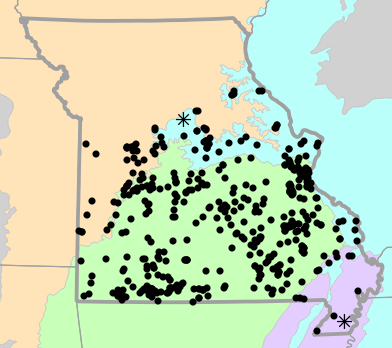
Natural Divisions Locality Map
Natural Divisions and Sections locality map for Sceloporus consobrinus (Prairie Lizard).
Map created 15 April 2026.
Major Watersheds Locality Map

Major Watersheds locality map for Sceloporus consobrinus (Prairie Lizard).
Map created 15 April 2026.
Level I Ecoregion Locality Map

Level I Ecoregion locality map for Sceloporus consobrinus (Prairie Lizard).
Map created 15 April 2026.
Level II Ecoregion Locality Map
Level II Ecoregion locality map for Sceloporus consobrinus (Prairie Lizard).
Map created 15 April 2026.
Level III Ecoregion Locality Map
Level III Ecoregion locality map for Sceloporus consobrinus (Prairie Lizard).
Map created 15 April 2026.
Level IV Ecoregion Locality Map

Level IV Ecoregion locality map for Sceloporus consobrinus (Prairie Lizard).
Map created 15 April 2026.
Native Status
Sceloporus consobrinus (Prairie Lizard) is native to Missouri.
Collection Summary
Sceloporus consobrinus (Prairie Lizard) has a total of 855 valid, non-duplicated collections representing 76 counties and 437 localities. There are a total of 243 collectors and 385 collection dates for the species. This results in a total of 467 expeditions for the species, a measure of unique date / collector(s) combinations. The earliest collection year for the species in Missouri is 1888 and its most recent collection year is 2025. The earliest and latest collection dates (independent of earliest and most recent collection years) are January 9 and November 9, respectively. If you have a new record to report, read the New Records section of the FAQ.
Collection Summary by County
| County | Localities | Collections | Collectors | Dates | Expeditions | Earliest Year | Latest Year | |
|---|---|---|---|---|---|---|---|---|
 | Barry | 13 | 39 | 13 | 17 | 19 | 1927 | 2025 |
| Barton | 4 | 4 | 2 | 4 | 4 | 1990 | 2022 |
| Benton | 11 | 12 | 11 | 10 | 10 | 1950 | 2017 |
| Bollinger | 3 | 3 | 3 | 3 | 3 | 1935 | 1956 |
| Boone | 12 | 28 | 12 | 17 | 18 | 1944 | 2009 |
| Butler | 4 | 7 | 4 | 6 | 6 | 1898 | 1995 |
| Callaway | 3 | 3 | 1 | 3 | 3 | 2000 | 2025 |
| Camden | 7 | 13 | 5 | 6 | 6 | 1956 | 1978 |
| Cape Girardeau | 4 | 4 | 3 | 4 | 4 | 1914 | 1996 |
| Carter | 12 | 22 | 17 | 13 | 17 | 1930 | 2024 |
| Cass | 2 | 2 | 2 | 2 | 2 | 1940 | 1964 |
| Cedar | 3 | 3 | 4 | 3 | 3 | 1982 | 2007 |
| Christian | 10 | 13 | 14 | 11 | 11 | 1954 | 2024 |
| Cole | 2 | 2 | 2 | 2 | 2 | 2005 | 2012 |
| Cooper | 2 | 2 | 2 | 2 | 2 | 1968 | 2008 |
| Crawford | 10 | 18 | 12 | 9 | 15 | 1902 | 2013 |
| Dade | 2 | 2 | 2 | 2 | 2 | 1982 | 2003 |
| Dallas | 2 | 3 | 4 | 2 | 2 | 1939 | 2000 |
| Dent | 8 | 18 | 12 | 9 | 13 | 1956 | 2019 |
| Douglas | 1 | 1 | 3 | 1 | 1 | 2004 | 2004 |
| Dunklin | 2 | 3 | 2 | 2 | 2 | 1962 | 1964 |
| Franklin | 2 | 3 | 3 | 2 | 3 | 1931 | 1931 |
| Gasconade | 2 | 3 | 4 | 2 | 3 | 1965 | 2002 |
| Greene | 6 | 7 | 6 | 6 | 6 | 1959 | 2002 |
| Henry | 3 | 3 | 3 | 3 | 3 | 1959 | 1991 |
| Hickory | 4 | 5 | 5 | 4 | 5 | 1961 | 1969 |
| Howard | 1 | 1 | 1 | 1 | 1 | ||
| Howell | 3 | 5 | 2 | 3 | 3 | 1953 | 2002 |
| Iron | 13 | 23 | 10 | 10 | 10 | 1923 | 2020 |
| Jasper | 3 | 11 | 2 | 4 | 4 | 1932 | 2013 |
| Jefferson | 34 | 46 | 19 | 18 | 23 | 1908 | 1987 |
| Johnson | 11 | 34 | 10 | 14 | 15 | 1946 | 1993 |
| Laclede | 2 | 3 | 2 | 2 | 2 | 1964 | 1982 |
| Lawrence | 3 | 3 | 5 | 3 | 3 | 1931 | 2007 |
| Lincoln | 3 | 4 | 3 | 4 | 4 | 1964 | 2009 |
| Madison | 6 | 13 | 7 | 8 | 8 | 1933 | 2020 |
| Maries | 3 | 9 | 3 | 3 | 3 | 1905 | 1982 |
| McDonald | 3 | 6 | 3 | 4 | 4 | 1906 | 1972 |
| Miller | 10 | 10 | 11 | 9 | 10 | 1969 | 2014 |
| Moniteau | 1 | 1 | 2 | 1 | 1 | 1992 | 1992 |
| Monroe | 4 | 4 | 2 | 4 | 4 | 2008 | 2021 |
| Montgomery | 3 | 8 | 3 | 4 | 4 | 1901 | 2018 |
| Morgan | 5 | 11 | 5 | 7 | 7 | 1902 | 2002 |
| New Madrid | 1 | 1 | 1 | 1 | 1 | ||
| Newton | 2 | 5 | 3 | 3 | 3 | 1944 | 1972 |
| Oregon | 6 | 8 | 5 | 6 | 6 | 1901 | 1973 |
| Osage | 4 | 61 | 5 | 8 | 11 | 1967 | 2013 |
| Ozark | 10 | 26 | 17 | 13 | 16 | 1902 | 2023 |
| Pemiscot | 1 | 1 | 1 | 1 | 1 | ||
| Perry | 3 | 3 | 4 | 3 | 3 | 1941 | 2011 |
| Pettis | 6 | 9 | 5 | 5 | 5 | 1940 | 1999 |
| Phelps | 14 | 25 | 17 | 12 | 14 | 1945 | 2022 |
| Pike | 2 | 2 | 2 | 1 | 2 | 1978 | 1978 |
| Polk | 2 | 2 | 3 | 2 | 2 | 2003 | 2005 |
| Pulaski | 5 | 8 | 4 | 6 | 6 | 1929 | 1973 |
| Randolph | 2 | 2 | 1 | 2 | 2 | 2000 | 2001 |
| Reynolds | 13 | 21 | 16 | 11 | 16 | 1911 | 2020 |
| Ripley | 6 | 10 | 6 | 6 | 6 | 1939 | 2008 |
| Saint Charles | 3 | 5 | 4 | 4 | 4 | 1940 | 2008 |
| Saint Clair | 13 | 32 | 8 | 13 | 13 | 1938 | 2012 |
| Sainte Genevieve | 3 | 4 | 2 | 3 | 3 | 1931 | 1992 |
| Saint Francois | 6 | 6 | 7 | 6 | 6 | 1937 | 2008 |
| Saint Louis | 8 | 18 | 8 | 9 | 9 | 1888 | 1967 |
| Saline | 2 | 3 | 2 | 2 | 2 | 1940 | 1940 |
| Scott | 2 | 2 | 2 | 2 | 2 | 2001 | 2005 |
| Shannon | 15 | 25 | 21 | 16 | 17 | 1932 | 2010 |
| Stoddard | 2 | 4 | 4 | 2 | 3 | 1938 | 1967 |
| Stone | 11 | 27 | 11 | 17 | 17 | 1892 | 1973 |
| Taney | 25 | 60 | 30 | 35 | 44 | 1951 | 2024 |
| Texas | 2 | 3 | 2 | 2 | 2 | 1982 | 1982 |
| Vernon | 2 | 2 | 2 | 2 | 2 | 1937 | 1937 |
| Warren | 1 | 1 | 1 | 1 | 1 | 2000 | 2000 |
| Washington | 7 | 27 | 13 | 7 | 13 | 1909 | 2008 |
| Wayne | 9 | 23 | 8 | 10 | 10 | 1939 | 2010 |
| Webster | 3 | 4 | 3 | 3 | 3 | 1932 | 2003 |
| Wright | 3 | 6 | 5 | 5 | 6 | 1932 | 2002 |
Potential County Records
| Likelihood | County | Rationale | Ecoregion / Watershed | |
|---|---|---|---|---|
 | 2 | Jackson | Same Level IV ecoregion, within 5 miles | Wooded Osage Plains |
| 2 | Ralls | Same Level IV ecoregion, within 5 miles | River Hills |
| 2 | Ralls | Same Level IV ecoregion, within 5 miles | Upper Mississippi Alluvial Plain |
| 4 | Audrain | Same Level IV ecoregion, within 10 miles | River Hills |
| 4 | Audrain | Same Level IV ecoregion, within 10 miles | Claypan Prairie |
| 4 | Bates | Same Level IV ecoregion, within 10 miles | Cherokee Plains |
| 4 | Marion | Same Level IV ecoregion, within 10 miles | River Hills |
| 4 | Marion | Same Level IV ecoregion, within 10 miles | Upper Mississippi Alluvial Plain |
 | 6 | Carroll | Same Level IV ecoregion, within 20 miles | Rolling Loess Prairies |
| 6 | Chariton | Same Level IV ecoregion, within 20 miles | Rolling Loess Prairies |
| 6 | Lafayette | Same Level IV ecoregion, within 20 miles | Rolling Loess Prairies |
| 6 | Lafayette | Same Level IV ecoregion, within 20 miles | Wooded Osage Plains |
| 6 | Mississippi | Same Level IV ecoregion, within 20 miles | St. Francis Lowlands |
| 6 | Shelby | Same Level IV ecoregion, within 20 miles | River Hills |
 | 8 | Lewis | Same Level IV ecoregion, within 30 miles | Upper Mississippi Alluvial Plain |
| 8 | Macon | Same Level IV ecoregion, within 30 miles | Claypan Prairie |
| 9 | Platte | Same Level III ecoregion, within 30 miles | Central Irregular Plains |
Linnaean Classification
- Kingdom:
- Animalia - Animals
- Phylum:
- Chordata - Chordates
- Subphylum:
- Vertebrata - Vertebrates
- Class:
- Reptilia Laurenti, 1768 - Reptiles
- Order:
- Squamata Oppel, 1811 - Lizards and Snakes
- Family:
- Phrynosomatidae Fitzinger, 1843 - Sand and Spiny Lizards
- Genus:
- Sceloporus Wiegmann, 1828 - Spiny Lizards
- Species:
- Sceloporus consobrinus Baird and Girard, 1853 - Prairie Lizard
Recent Taxonomic Synonyms
- Sceloporus undulatus